You are here: Home > Network List > CI - Caltech Regional Seismic Network Stations List
> Station MPM Manuel Prospect Mine, California, USA > Earthquake Result Viewer
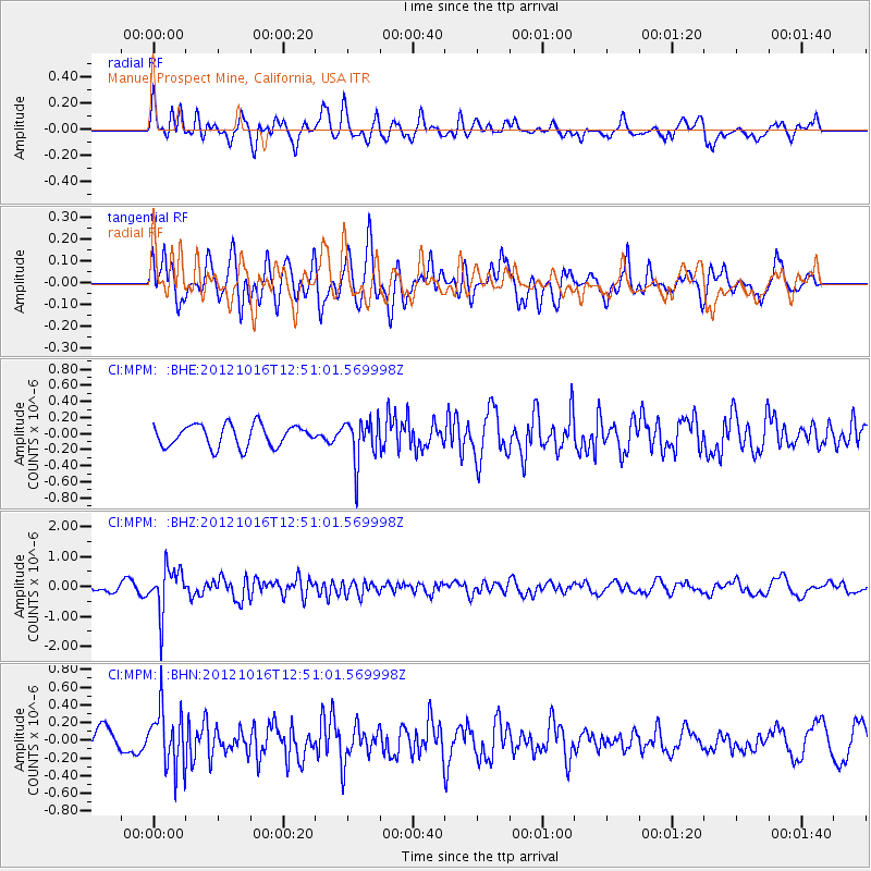
MPM Manuel Prospect Mine, California, USA - Earthquake Result Viewer
*The percent match for this event was below the threshold and hence no stack was calculated.
| Earthquake location: |
Kuril Islands |
| Earthquake latitude/longitude: |
49.6/156.4 |
| Earthquake time(UTC): |
2012/10/16 (290) 12:41:25 GMT |
| Earthquake Depth: |
81 km |
| Earthquake Magnitude: |
6.2 MB, 5.6 MW, 5.6 MW |
| Earthquake Catalog/Contributor: |
WHDF/NEIC |
|
| Network: |
CI Caltech Regional Seismic Network |
| Station: |
MPM Manuel Prospect Mine, California, USA |
| Lat/Lon: |
36.06 N/117.49 W |
| Elevation: |
185 m |
|
| Distance: |
61.2 deg |
| Az: |
67.249 deg |
| Baz: |
312.25 deg |
| Ray Param: |
$rayparam |
*The percent match for this event was below the threshold and hence was not used in the summary stack. |
|
| Radial Match: |
62.55669 % |
| Radial Bump: |
400 |
| Transverse Match: |
65.43036 % |
| Transverse Bump: |
400 |
| SOD ConfigId: |
478790 |
| Insert Time: |
2013-02-23 04:54:50.682 +0000 |
| GWidth: |
2.5 |
| Max Bumps: |
400 |
| Tol: |
0.001 |
|
Signal To Noise
| Channel | StoN | STA | LTA |
| CI:MPM: :BHZ:20121016T12:51:01.569998Z | 6.3061175 | 7.3728864E-7 | 1.1691642E-7 |
| CI:MPM: :BHN:20121016T12:51:01.569998Z | 2.014992 | 3.2729514E-7 | 1.6243E-7 |
| CI:MPM: :BHE:20121016T12:51:01.569998Z | 1.9958704 | 2.6912497E-7 | 1.3484092E-7 |
| Arrivals |
| Ps | |
| PpPs | |
| PsPs/PpSs | |


