You are here: Home > Network List > CI - Caltech Regional Seismic Network Stations List
> Station SLA SLA, Trona, CA, USA > Earthquake Result Viewer
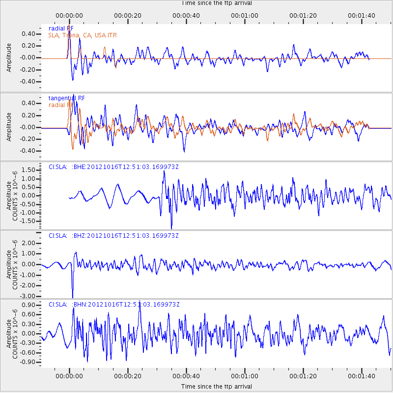
SLA SLA, Trona, CA, USA - Earthquake Result Viewer
*The percent match for this event was below the threshold and hence no stack was calculated.
| Earthquake location: |
Kuril Islands |
| Earthquake latitude/longitude: |
49.6/156.4 |
| Earthquake time(UTC): |
2012/10/16 (290) 12:41:25 GMT |
| Earthquake Depth: |
81 km |
| Earthquake Magnitude: |
6.2 MB, 5.6 MW, 5.6 MW |
| Earthquake Catalog/Contributor: |
WHDF/NEIC |
|
| Network: |
CI Caltech Regional Seismic Network |
| Station: |
SLA SLA, Trona, CA, USA |
| Lat/Lon: |
35.89 N/117.28 W |
| Elevation: |
1174 m |
|
| Distance: |
61.5 deg |
| Az: |
67.262 deg |
| Baz: |
312.376 deg |
| Ray Param: |
$rayparam |
*The percent match for this event was below the threshold and hence was not used in the summary stack. |
|
| Radial Match: |
66.85159 % |
| Radial Bump: |
400 |
| Transverse Match: |
76.641884 % |
| Transverse Bump: |
400 |
| SOD ConfigId: |
478790 |
| Insert Time: |
2013-02-23 04:55:19.419 +0000 |
| GWidth: |
2.5 |
| Max Bumps: |
400 |
| Tol: |
0.001 |
|
Signal To Noise
| Channel | StoN | STA | LTA |
| CI:SLA: :BHZ:20121016T12:51:03.169973Z | 7.23208 | 8.964976E-7 | 1.2396123E-7 |
| CI:SLA: :BHN:20121016T12:51:03.169973Z | 3.309567 | 3.6325727E-7 | 1.0975976E-7 |
| CI:SLA: :BHE:20121016T12:51:03.169973Z | 2.1399302 | 6.3905054E-7 | 2.986315E-7 |
| Arrivals |
| Ps | |
| PpPs | |
| PsPs/PpSs | |


