You are here: Home > Network List > CI - Caltech Regional Seismic Network Stations List
> Station SMM Simmler, CA, USA > Earthquake Result Viewer
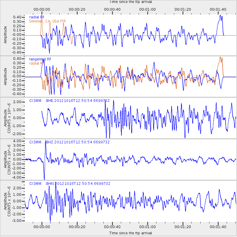
SMM Simmler, CA, USA - Earthquake Result Viewer
*The percent match for this event was below the threshold and hence no stack was calculated.
| Earthquake location: |
Kuril Islands |
| Earthquake latitude/longitude: |
49.6/156.4 |
| Earthquake time(UTC): |
2012/10/16 (290) 12:41:25 GMT |
| Earthquake Depth: |
81 km |
| Earthquake Magnitude: |
6.2 MB, 5.6 MW, 5.6 MW |
| Earthquake Catalog/Contributor: |
WHDF/NEIC |
|
| Network: |
CI Caltech Regional Seismic Network |
| Station: |
SMM Simmler, CA, USA |
| Lat/Lon: |
35.31 N/120.00 W |
| Elevation: |
599 m |
|
| Distance: |
60.2 deg |
| Az: |
69.448 deg |
| Baz: |
311.869 deg |
| Ray Param: |
$rayparam |
*The percent match for this event was below the threshold and hence was not used in the summary stack. |
|
| Radial Match: |
56.674408 % |
| Radial Bump: |
400 |
| Transverse Match: |
73.22431 % |
| Transverse Bump: |
400 |
| SOD ConfigId: |
478790 |
| Insert Time: |
2013-02-23 04:55:46.174 +0000 |
| GWidth: |
2.5 |
| Max Bumps: |
400 |
| Tol: |
0.001 |
|
Signal To Noise
| Channel | StoN | STA | LTA |
| CI:SMM: :BHZ:20121016T12:50:54.669973Z | 5.6451592 | 1.652009E-6 | 2.9264172E-7 |
| CI:SMM: :BHN:20121016T12:50:54.669973Z | 2.1323326 | 1.1911463E-6 | 5.586119E-7 |
| CI:SMM: :BHE:20121016T12:50:54.669973Z | 0.7330425 | 4.1168522E-7 | 5.616117E-7 |
| Arrivals |
| Ps | |
| PpPs | |
| PsPs/PpSs | |


