You are here: Home > Network List > G - GEOSCOPE Stations List
> Station WUS Wushi, Xinjiang Uygur, China > Earthquake Result Viewer
WUS Wushi, Xinjiang Uygur, China - Earthquake Result Viewer

| Earthquake location: |
Mindoro, Philippines |
| Earthquake latitude/longitude: |
13.5/121.1 |
| Earthquake time(UTC): |
1994/11/14 (318) 19:15:30 GMT |
| Earthquake Depth: |
33 km |
| Earthquake Magnitude: |
6.1 MB, 7.1 MS, 7.1 UNKNOWN, 7.1 MW |
| Earthquake Catalog/Contributor: |
WHDF/NEIC |
|
| Network: |
G GEOSCOPE |
| Station: |
WUS Wushi, Xinjiang Uygur, China |
| Lat/Lon: |
41.20 N/79.22 E |
| Elevation: |
1457 m |
|
| Distance: |
45.6 deg |
| Az: |
315.22 deg |
| Baz: |
114.789 deg |
| Ray Param: |
0.07107403 |
| Estimated Moho Depth: |
68.5 km |
| Estimated Crust Vp/Vs: |
1.92 |
| Assumed Crust Vp: |
6.353 km/s |
| Estimated Crust Vs: |
3.3 km/s |
| Estimated Crust Poisson's Ratio: |
0.32 |
|
| Radial Match: |
95.78079 % |
| Radial Bump: |
400 |
| Transverse Match: |
86.09194 % |
| Transverse Bump: |
400 |
| SOD ConfigId: |
4480 |
| Insert Time: |
2010-02-27 00:59:43.536 +0000 |
| GWidth: |
2.5 |
| Max Bumps: |
400 |
| Tol: |
0.001 |
|
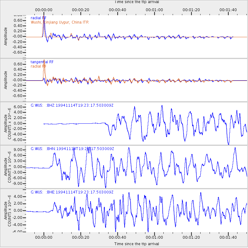
Signal To Noise
| Channel | StoN | STA | LTA |
| G:WUS: :BHN:19941114T19:23:17.503009Z | 3.6870978 | 5.089237E-7 | 1.3802827E-7 |
| G:WUS: :BHE:19941114T19:23:17.503009Z | 2.4719002 | 1.925429E-7 | 7.7892665E-8 |
| G:WUS: :BHZ:19941114T19:23:17.503009Z | 2.709391 | 2.4736414E-7 | 9.129879E-8 |
| Arrivals |
| Ps | 11 SECOND |
| PpPs | 30 SECOND |
| PsPs/PpSs | 40 SECOND |


