You are here: Home > Network List > CI - Caltech Regional Seismic Network Stations List
> Station BFS Mt Baldy Forest Station > Earthquake Result Viewer
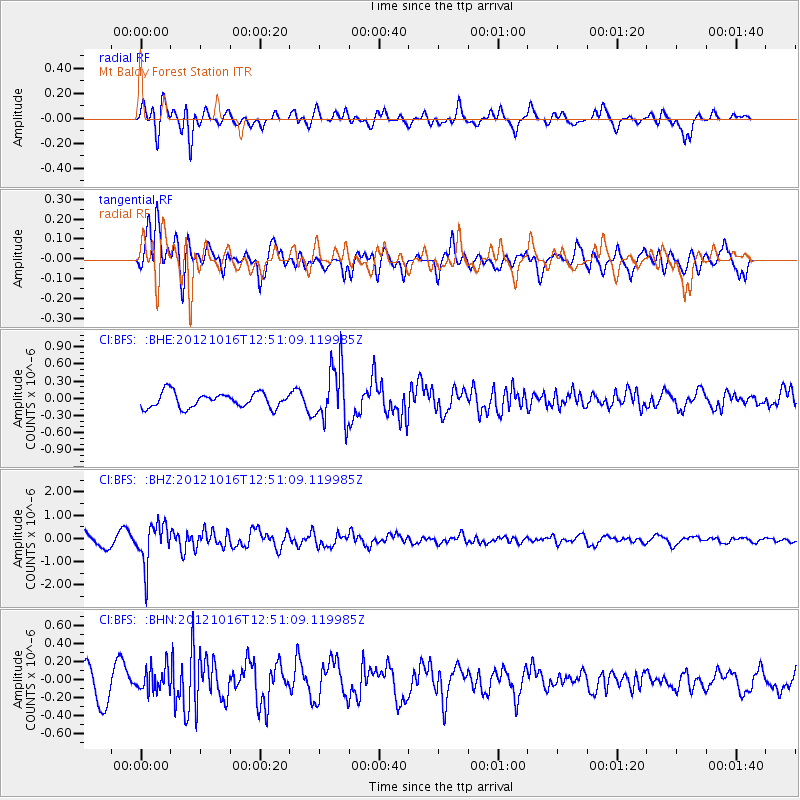
BFS Mt Baldy Forest Station - Earthquake Result Viewer
*The percent match for this event was below the threshold and hence no stack was calculated.
| Earthquake location: |
Kuril Islands |
| Earthquake latitude/longitude: |
49.6/156.4 |
| Earthquake time(UTC): |
2012/10/16 (290) 12:41:25 GMT |
| Earthquake Depth: |
81 km |
| Earthquake Magnitude: |
6.2 MB, 5.6 MW, 5.6 MW |
| Earthquake Catalog/Contributor: |
WHDF/NEIC |
|
| Network: |
CI Caltech Regional Seismic Network |
| Station: |
BFS Mt Baldy Forest Station |
| Lat/Lon: |
34.24 N/117.66 W |
| Elevation: |
1312 m |
|
| Distance: |
62.4 deg |
| Az: |
68.872 deg |
| Baz: |
312.92 deg |
| Ray Param: |
$rayparam |
*The percent match for this event was below the threshold and hence was not used in the summary stack. |
|
| Radial Match: |
68.777596 % |
| Radial Bump: |
400 |
| Transverse Match: |
76.53027 % |
| Transverse Bump: |
400 |
| SOD ConfigId: |
478790 |
| Insert Time: |
2013-02-23 04:56:16.631 +0000 |
| GWidth: |
2.5 |
| Max Bumps: |
400 |
| Tol: |
0.001 |
|
Signal To Noise
| Channel | StoN | STA | LTA |
| CI:BFS: :BHZ:20121016T12:51:09.119985Z | 2.4881253 | 8.8912685E-7 | 3.573481E-7 |
| CI:BFS: :BHN:20121016T12:51:09.119985Z | 0.6626771 | 1.3255143E-7 | 2.0002418E-7 |
| CI:BFS: :BHE:20121016T12:51:09.119985Z | 3.7815378 | 4.9132586E-7 | 1.2992753E-7 |
| Arrivals |
| Ps | |
| PpPs | |
| PsPs/PpSs | |


