You are here: Home > Network List > CN - Canadian National Seismograph Network Stations List
> Station INK INUVIK, NT > Earthquake Result Viewer
INK INUVIK, NT - Earthquake Result Viewer
*The percent match for this event was below the threshold and hence no stack was calculated.
| Earthquake location: |
Kuril Islands |
| Earthquake latitude/longitude: |
49.6/156.4 |
| Earthquake time(UTC): |
2012/10/16 (290) 12:41:25 GMT |
| Earthquake Depth: |
81 km |
| Earthquake Magnitude: |
6.2 MB, 5.6 MW, 5.6 MW |
| Earthquake Catalog/Contributor: |
WHDF/NEIC |
|
| Network: |
CN Canadian National Seismograph Network |
| Station: |
INK INUVIK, NT |
| Lat/Lon: |
68.31 N/133.53 W |
| Elevation: |
44 m |
|
| Distance: |
38.0 deg |
| Az: |
34.557 deg |
| Baz: |
277.111 deg |
| Ray Param: |
$rayparam |
*The percent match for this event was below the threshold and hence was not used in the summary stack. |
|
| Radial Match: |
68.3774 % |
| Radial Bump: |
400 |
| Transverse Match: |
44.305874 % |
| Transverse Bump: |
400 |
| SOD ConfigId: |
478790 |
| Insert Time: |
2013-02-23 04:57:17.870 +0000 |
| GWidth: |
2.5 |
| Max Bumps: |
400 |
| Tol: |
0.001 |
|
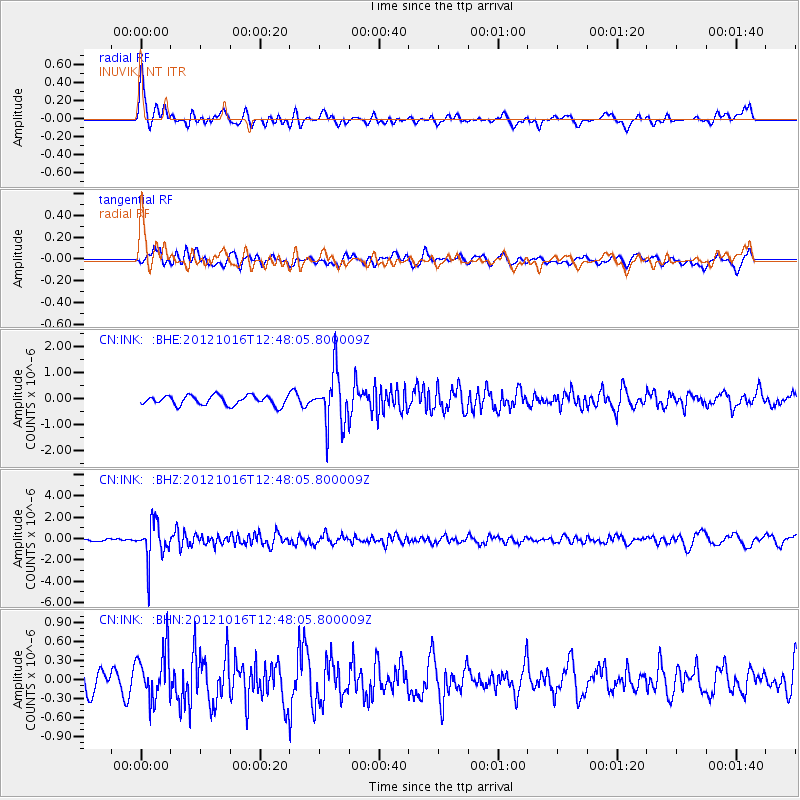
Signal To Noise
| Channel | StoN | STA | LTA |
| CN:INK: :BHZ:20121016T12:48:05.800009Z | 9.344792 | 1.7510768E-6 | 1.8738531E-7 |
| CN:INK: :BHN:20121016T12:48:05.800009Z | 1.7750704 | 3.8601908E-7 | 2.174669E-7 |
| CN:INK: :BHE:20121016T12:48:05.800009Z | 5.5223584 | 1.0260195E-6 | 1.8579374E-7 |
| Arrivals |
| Ps | |
| PpPs | |
| PsPs/PpSs | |


