You are here: Home > Network List > G - GEOSCOPE Stations List
> Station IVI Ivittuut, Greenland > Earthquake Result Viewer
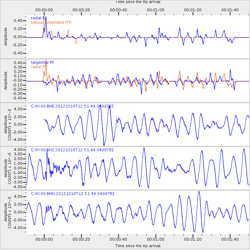
IVI Ivittuut, Greenland - Earthquake Result Viewer
*The percent match for this event was below the threshold and hence no stack was calculated.
| Earthquake location: |
Kuril Islands |
| Earthquake latitude/longitude: |
49.6/156.4 |
| Earthquake time(UTC): |
2012/10/16 (290) 12:41:25 GMT |
| Earthquake Depth: |
81 km |
| Earthquake Magnitude: |
6.2 MB, 5.6 MW, 5.6 MW |
| Earthquake Catalog/Contributor: |
WHDF/NEIC |
|
| Network: |
G GEOSCOPE |
| Station: |
IVI Ivittuut, Greenland |
| Lat/Lon: |
61.21 N/48.17 W |
| Elevation: |
15 m |
|
| Distance: |
67.8 deg |
| Az: |
12.58 deg |
| Baz: |
342.987 deg |
| Ray Param: |
$rayparam |
*The percent match for this event was below the threshold and hence was not used in the summary stack. |
|
| Radial Match: |
48.336254 % |
| Radial Bump: |
252 |
| Transverse Match: |
60.40606 % |
| Transverse Bump: |
398 |
| SOD ConfigId: |
478790 |
| Insert Time: |
2013-02-23 04:59:21.033 +0000 |
| GWidth: |
2.5 |
| Max Bumps: |
400 |
| Tol: |
0.001 |
|
Signal To Noise
| Channel | StoN | STA | LTA |
| G:IVI:00:BHZ:20121016T12:51:44.049978Z | 0.7584579 | 1.6528276E-6 | 2.179195E-6 |
| G:IVI:00:BHN:20121016T12:51:44.049978Z | 0.9171189 | 1.5526974E-6 | 1.6930165E-6 |
| G:IVI:00:BHE:20121016T12:51:44.049978Z | 2.0384748 | 3.5826513E-6 | 1.7575156E-6 |
| Arrivals |
| Ps | |
| PpPs | |
| PsPs/PpSs | |


