You are here: Home > Network List > IC - New China Digital Seismograph Network Stations List
> Station LSA Tibet, China > Earthquake Result Viewer
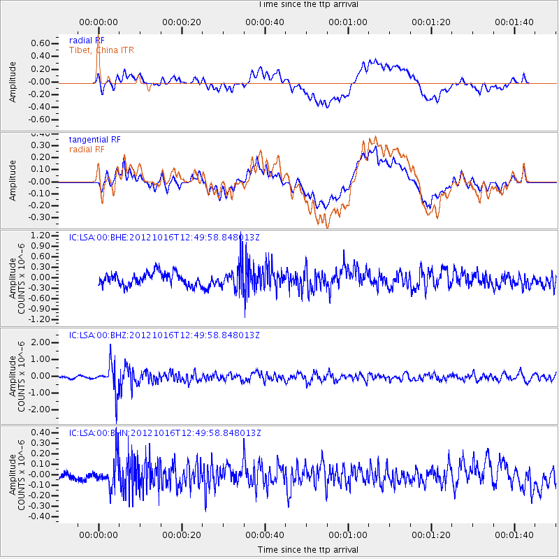
LSA Tibet, China - Earthquake Result Viewer
*The percent match for this event was below the threshold and hence no stack was calculated.
| Earthquake location: |
Kuril Islands |
| Earthquake latitude/longitude: |
49.6/156.4 |
| Earthquake time(UTC): |
2012/10/16 (290) 12:41:25 GMT |
| Earthquake Depth: |
81 km |
| Earthquake Magnitude: |
6.2 MB, 5.6 MW, 5.6 MW |
| Earthquake Catalog/Contributor: |
WHDF/NEIC |
|
| Network: |
IC New China Digital Seismograph Network |
| Station: |
LSA Tibet, China |
| Lat/Lon: |
29.70 N/91.13 E |
| Elevation: |
3660 m |
|
| Distance: |
52.4 deg |
| Az: |
273.23 deg |
| Baz: |
48.277 deg |
| Ray Param: |
$rayparam |
*The percent match for this event was below the threshold and hence was not used in the summary stack. |
|
| Radial Match: |
60.473343 % |
| Radial Bump: |
400 |
| Transverse Match: |
60.666237 % |
| Transverse Bump: |
400 |
| SOD ConfigId: |
478790 |
| Insert Time: |
2013-02-23 04:59:51.973 +0000 |
| GWidth: |
2.5 |
| Max Bumps: |
400 |
| Tol: |
0.001 |
|
Signal To Noise
| Channel | StoN | STA | LTA |
| IC:LSA:00:BHZ:20121016T12:49:58.848013Z | 12.820023 | 8.194135E-7 | 6.39167E-8 |
| IC:LSA:00:BHN:20121016T12:49:58.848013Z | 3.920445 | 1.341533E-7 | 3.4218896E-8 |
| IC:LSA:00:BHE:20121016T12:49:58.848013Z | 1.9924959 | 3.4763485E-7 | 1.7447205E-7 |
| Arrivals |
| Ps | |
| PpPs | |
| PsPs/PpSs | |


