You are here: Home > Network List > IC - New China Digital Seismograph Network Stations List
> Station ENH Enshi, Hubei Province, China > Earthquake Result Viewer
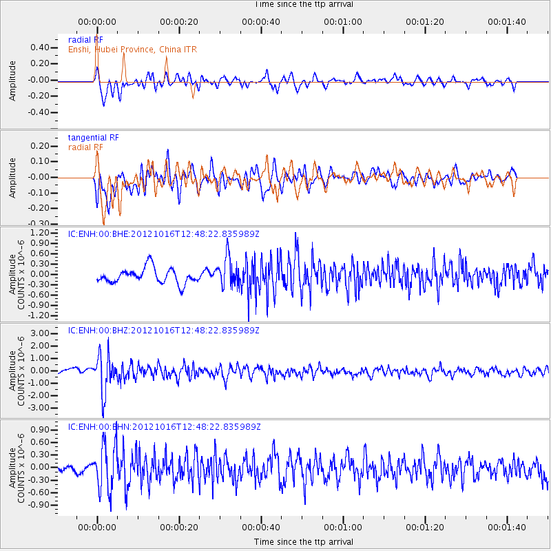
ENH Enshi, Hubei Province, China - Earthquake Result Viewer
*The percent match for this event was below the threshold and hence no stack was calculated.
| Earthquake location: |
Kuril Islands |
| Earthquake latitude/longitude: |
49.6/156.4 |
| Earthquake time(UTC): |
2012/10/16 (290) 12:41:25 GMT |
| Earthquake Depth: |
81 km |
| Earthquake Magnitude: |
6.2 MB, 5.6 MW, 5.6 MW |
| Earthquake Catalog/Contributor: |
WHDF/NEIC |
|
| Network: |
IC New China Digital Seismograph Network |
| Station: |
ENH Enshi, Hubei Province, China |
| Lat/Lon: |
30.28 N/109.49 E |
| Elevation: |
500 m |
|
| Distance: |
40.1 deg |
| Az: |
259.046 deg |
| Baz: |
47.574 deg |
| Ray Param: |
$rayparam |
*The percent match for this event was below the threshold and hence was not used in the summary stack. |
|
| Radial Match: |
72.47602 % |
| Radial Bump: |
400 |
| Transverse Match: |
56.652073 % |
| Transverse Bump: |
400 |
| SOD ConfigId: |
478790 |
| Insert Time: |
2013-02-23 04:59:54.592 +0000 |
| GWidth: |
2.5 |
| Max Bumps: |
400 |
| Tol: |
0.001 |
|
Signal To Noise
| Channel | StoN | STA | LTA |
| IC:ENH:00:BHZ:20121016T12:48:22.835989Z | 5.8702364 | 1.5010819E-6 | 2.5571063E-7 |
| IC:ENH:00:BHN:20121016T12:48:22.835989Z | 3.0516644 | 5.641799E-7 | 1.8487614E-7 |
| IC:ENH:00:BHE:20121016T12:48:22.835989Z | 1.9846712 | 4.317082E-7 | 2.1752128E-7 |
| Arrivals |
| Ps | |
| PpPs | |
| PsPs/PpSs | |


