You are here: Home > Network List > IU - Global Seismograph Network (GSN - IRIS/USGS) Stations List
> Station GRFO Grafenberg, Germany > Earthquake Result Viewer
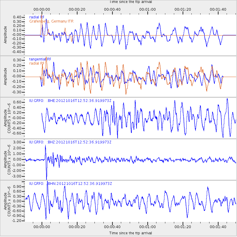
GRFO Grafenberg, Germany - Earthquake Result Viewer
*The percent match for this event was below the threshold and hence no stack was calculated.
| Earthquake location: |
Kuril Islands |
| Earthquake latitude/longitude: |
49.6/156.4 |
| Earthquake time(UTC): |
2012/10/16 (290) 12:41:25 GMT |
| Earthquake Depth: |
81 km |
| Earthquake Magnitude: |
6.2 MB, 5.6 MW, 5.6 MW |
| Earthquake Catalog/Contributor: |
WHDF/NEIC |
|
| Network: |
IU Global Seismograph Network (GSN - IRIS/USGS) |
| Station: |
GRFO Grafenberg, Germany |
| Lat/Lon: |
49.69 N/11.22 E |
| Elevation: |
384 m |
|
| Distance: |
76.7 deg |
| Az: |
337.62 deg |
| Baz: |
22.415 deg |
| Ray Param: |
$rayparam |
*The percent match for this event was below the threshold and hence was not used in the summary stack. |
|
| Radial Match: |
57.14 % |
| Radial Bump: |
400 |
| Transverse Match: |
65.60756 % |
| Transverse Bump: |
400 |
| SOD ConfigId: |
478790 |
| Insert Time: |
2013-02-23 05:00:29.558 +0000 |
| GWidth: |
2.5 |
| Max Bumps: |
400 |
| Tol: |
0.001 |
|
Signal To Noise
| Channel | StoN | STA | LTA |
| IU:GRFO: :BHZ:20121016T12:52:36.919973Z | 5.3826866 | 1.0451502E-6 | 1.9416886E-7 |
| IU:GRFO: :BHN:20121016T12:52:36.919973Z | 2.308894 | 5.3105924E-7 | 2.3000591E-7 |
| IU:GRFO: :BHE:20121016T12:52:36.919973Z | 1.8887255 | 2.9712365E-7 | 1.5731436E-7 |
| Arrivals |
| Ps | |
| PpPs | |
| PsPs/PpSs | |


