You are here: Home > Network List > TA - USArray Transportable Network (new EarthScope stations) Stations List
> Station Y40A Okolona, AR, USA > Earthquake Result Viewer
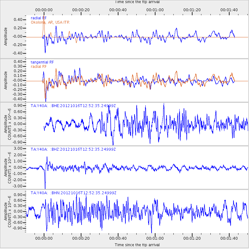
Y40A Okolona, AR, USA - Earthquake Result Viewer
*The percent match for this event was below the threshold and hence no stack was calculated.
| Earthquake location: |
Kuril Islands |
| Earthquake latitude/longitude: |
49.6/156.4 |
| Earthquake time(UTC): |
2012/10/16 (290) 12:41:25 GMT |
| Earthquake Depth: |
81 km |
| Earthquake Magnitude: |
6.2 MB, 5.6 MW, 5.6 MW |
| Earthquake Catalog/Contributor: |
WHDF/NEIC |
|
| Network: |
TA USArray Transportable Network (new EarthScope stations) |
| Station: |
Y40A Okolona, AR, USA |
| Lat/Lon: |
34.01 N/93.28 W |
| Elevation: |
117 m |
|
| Distance: |
76.4 deg |
| Az: |
53.295 deg |
| Baz: |
321.115 deg |
| Ray Param: |
$rayparam |
*The percent match for this event was below the threshold and hence was not used in the summary stack. |
|
| Radial Match: |
39.515984 % |
| Radial Bump: |
400 |
| Transverse Match: |
59.619705 % |
| Transverse Bump: |
400 |
| SOD ConfigId: |
478790 |
| Insert Time: |
2013-02-23 05:19:18.477 +0000 |
| GWidth: |
2.5 |
| Max Bumps: |
400 |
| Tol: |
0.001 |
|
Signal To Noise
| Channel | StoN | STA | LTA |
| TA:Y40A: :BHZ:20121016T12:52:35.24999Z | 5.1816115 | 9.378951E-7 | 1.8100452E-7 |
| TA:Y40A: :BHN:20121016T12:52:35.24999Z | 2.5666173 | 4.502247E-7 | 1.754156E-7 |
| TA:Y40A: :BHE:20121016T12:52:35.24999Z | 2.0814905 | 3.3869597E-7 | 1.6271801E-7 |
| Arrivals |
| Ps | |
| PpPs | |
| PsPs/PpSs | |


