You are here: Home > Network List > TA - USArray Transportable Network (new EarthScope stations) Stations List
> Station Z47A Carrollton, AL, USA > Earthquake Result Viewer
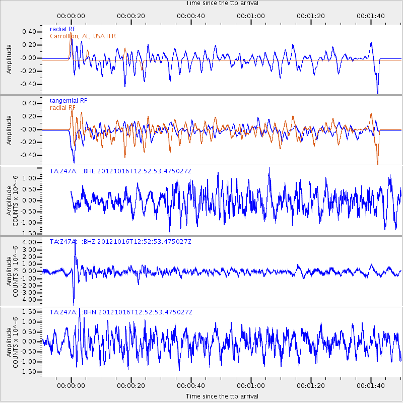
Z47A Carrollton, AL, USA - Earthquake Result Viewer
*The percent match for this event was below the threshold and hence no stack was calculated.
| Earthquake location: |
Kuril Islands |
| Earthquake latitude/longitude: |
49.6/156.4 |
| Earthquake time(UTC): |
2012/10/16 (290) 12:41:25 GMT |
| Earthquake Depth: |
81 km |
| Earthquake Magnitude: |
6.2 MB, 5.6 MW, 5.6 MW |
| Earthquake Catalog/Contributor: |
WHDF/NEIC |
|
| Network: |
TA USArray Transportable Network (new EarthScope stations) |
| Station: |
Z47A Carrollton, AL, USA |
| Lat/Lon: |
33.20 N/88.07 W |
| Elevation: |
65 m |
|
| Distance: |
79.7 deg |
| Az: |
50.29 deg |
| Baz: |
323.363 deg |
| Ray Param: |
$rayparam |
*The percent match for this event was below the threshold and hence was not used in the summary stack. |
|
| Radial Match: |
61.050774 % |
| Radial Bump: |
400 |
| Transverse Match: |
65.05281 % |
| Transverse Bump: |
400 |
| SOD ConfigId: |
478790 |
| Insert Time: |
2013-02-23 05:27:11.710 +0000 |
| GWidth: |
2.5 |
| Max Bumps: |
400 |
| Tol: |
0.001 |
|
Signal To Noise
| Channel | StoN | STA | LTA |
| TA:Z47A: :BHZ:20121016T12:52:53.475027Z | 7.337049 | 1.5179677E-6 | 2.0689077E-7 |
| TA:Z47A: :BHN:20121016T12:52:53.475027Z | 2.1659653 | 7.0089226E-7 | 3.2359347E-7 |
| TA:Z47A: :BHE:20121016T12:52:53.475027Z | 1.5804839 | 4.7049093E-7 | 2.976879E-7 |
| Arrivals |
| Ps | |
| PpPs | |
| PsPs/PpSs | |


