You are here: Home > Network List > TA - USArray Transportable Network (new EarthScope stations) Stations List
> Station H41A Junction City, WI, USA > Earthquake Result Viewer
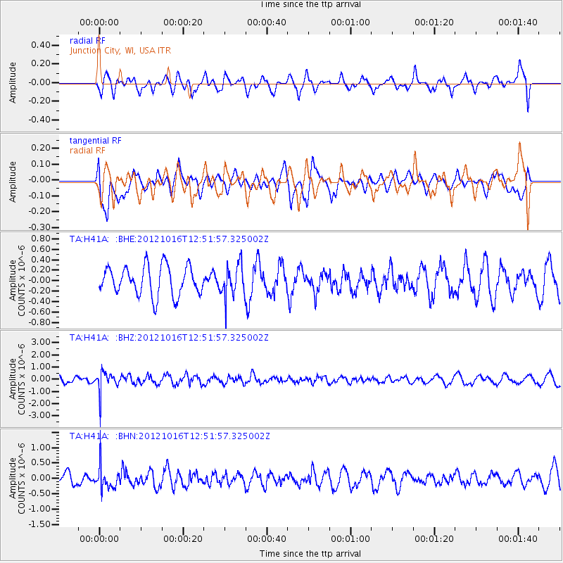
H41A Junction City, WI, USA - Earthquake Result Viewer
*The percent match for this event was below the threshold and hence no stack was calculated.
| Earthquake location: |
Kuril Islands |
| Earthquake latitude/longitude: |
49.6/156.4 |
| Earthquake time(UTC): |
2012/10/16 (290) 12:41:25 GMT |
| Earthquake Depth: |
81 km |
| Earthquake Magnitude: |
6.2 MB, 5.6 MW, 5.6 MW |
| Earthquake Catalog/Contributor: |
WHDF/NEIC |
|
| Network: |
TA USArray Transportable Network (new EarthScope stations) |
| Station: |
H41A Junction City, WI, USA |
| Lat/Lon: |
44.62 N/89.65 W |
| Elevation: |
348 m |
|
| Distance: |
69.9 deg |
| Az: |
44.042 deg |
| Baz: |
320.721 deg |
| Ray Param: |
$rayparam |
*The percent match for this event was below the threshold and hence was not used in the summary stack. |
|
| Radial Match: |
40.433105 % |
| Radial Bump: |
400 |
| Transverse Match: |
56.252525 % |
| Transverse Bump: |
400 |
| SOD ConfigId: |
478790 |
| Insert Time: |
2013-02-23 05:36:43.371 +0000 |
| GWidth: |
2.5 |
| Max Bumps: |
400 |
| Tol: |
0.001 |
|
Signal To Noise
| Channel | StoN | STA | LTA |
| TA:H41A: :BHZ:20121016T12:51:57.325002Z | 3.5325742 | 8.395795E-7 | 2.376679E-7 |
| TA:H41A: :BHN:20121016T12:51:57.325002Z | 2.436107 | 3.683395E-7 | 1.5120007E-7 |
| TA:H41A: :BHE:20121016T12:51:57.325002Z | 1.126843 | 3.143175E-7 | 2.7893637E-7 |
| Arrivals |
| Ps | |
| PpPs | |
| PsPs/PpSs | |


