You are here: Home > Network List > TA - USArray Transportable Network (new EarthScope stations) Stations List
> Station P46A Rosedale, IN, USA > Earthquake Result Viewer
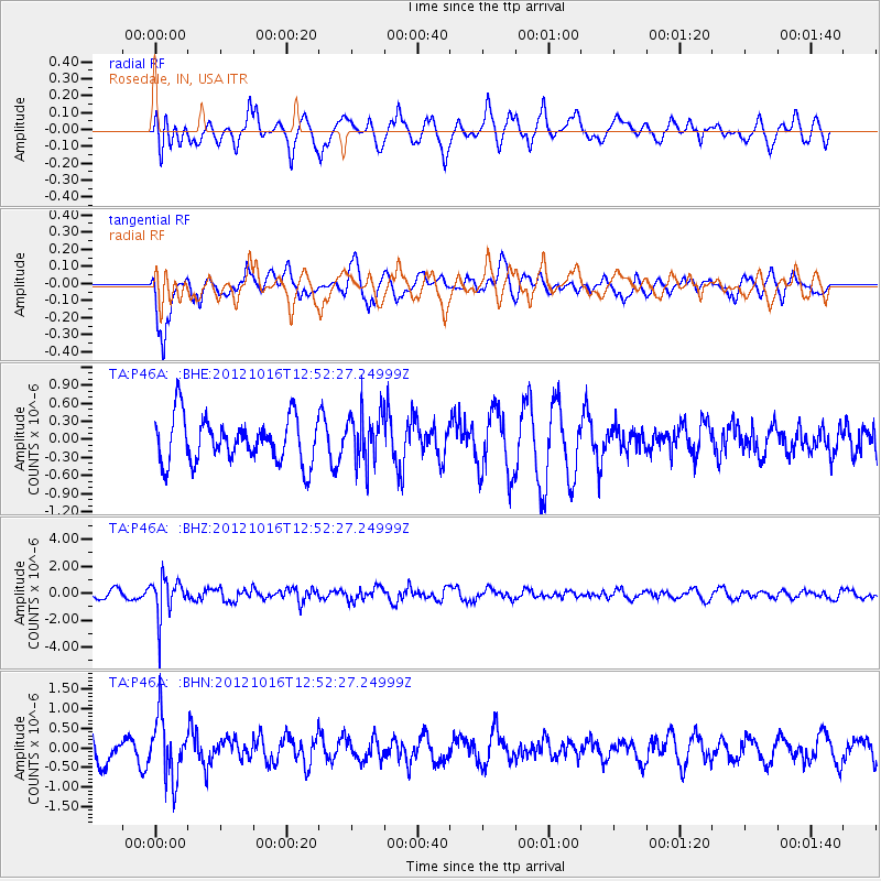
P46A Rosedale, IN, USA - Earthquake Result Viewer
*The percent match for this event was below the threshold and hence no stack was calculated.
| Earthquake location: |
Kuril Islands |
| Earthquake latitude/longitude: |
49.6/156.4 |
| Earthquake time(UTC): |
2012/10/16 (290) 12:41:25 GMT |
| Earthquake Depth: |
81 km |
| Earthquake Magnitude: |
6.2 MB, 5.6 MW, 5.6 MW |
| Earthquake Catalog/Contributor: |
WHDF/NEIC |
|
| Network: |
TA USArray Transportable Network (new EarthScope stations) |
| Station: |
P46A Rosedale, IN, USA |
| Lat/Lon: |
39.62 N/87.21 W |
| Elevation: |
194 m |
|
| Distance: |
75.0 deg |
| Az: |
45.779 deg |
| Baz: |
322.882 deg |
| Ray Param: |
$rayparam |
*The percent match for this event was below the threshold and hence was not used in the summary stack. |
|
| Radial Match: |
58.991505 % |
| Radial Bump: |
400 |
| Transverse Match: |
67.661026 % |
| Transverse Bump: |
400 |
| SOD ConfigId: |
478790 |
| Insert Time: |
2013-02-23 05:44:29.157 +0000 |
| GWidth: |
2.5 |
| Max Bumps: |
400 |
| Tol: |
0.001 |
|
Signal To Noise
| Channel | StoN | STA | LTA |
| TA:P46A: :BHZ:20121016T12:52:27.24999Z | 3.4733396 | 1.4329961E-6 | 4.1257013E-7 |
| TA:P46A: :BHN:20121016T12:52:27.24999Z | 2.827271 | 7.742865E-7 | 2.7386355E-7 |
| TA:P46A: :BHE:20121016T12:52:27.24999Z | 1.1367519 | 4.227079E-7 | 3.718559E-7 |
| Arrivals |
| Ps | |
| PpPs | |
| PsPs/PpSs | |


