You are here: Home > Network List > TA - USArray Transportable Network (new EarthScope stations) Stations List
> Station G03D McMinnville, OR, USA > Earthquake Result Viewer
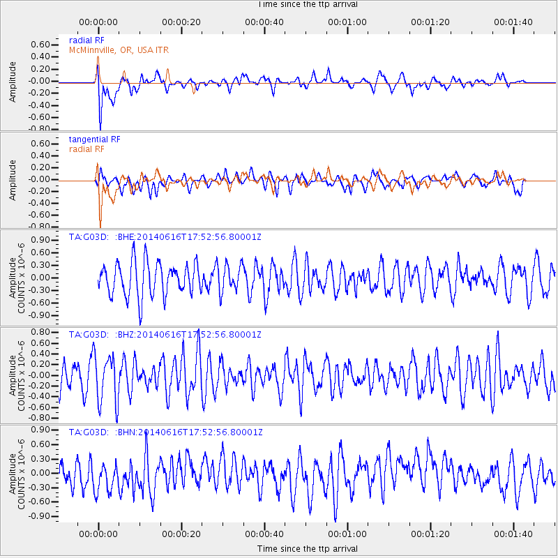
G03D McMinnville, OR, USA - Earthquake Result Viewer
*The percent match for this event was below the threshold and hence no stack was calculated.
| Earthquake location: |
Southeast Of Honshu, Japan |
| Earthquake latitude/longitude: |
33.9/139.7 |
| Earthquake time(UTC): |
2014/06/16 (167) 17:42:22 GMT |
| Earthquake Depth: |
132 km |
| Earthquake Magnitude: |
5.3 MW |
| Earthquake Catalog/Contributor: |
ISC/ISC |
|
| Network: |
TA USArray Transportable Network (new EarthScope stations) |
| Station: |
G03D McMinnville, OR, USA |
| Lat/Lon: |
45.21 N/123.26 W |
| Elevation: |
222 m |
|
| Distance: |
71.3 deg |
| Az: |
47.783 deg |
| Baz: |
299.423 deg |
| Ray Param: |
$rayparam |
*The percent match for this event was below the threshold and hence was not used in the summary stack. |
|
| Radial Match: |
53.446 % |
| Radial Bump: |
400 |
| Transverse Match: |
52.15895 % |
| Transverse Bump: |
400 |
| SOD ConfigId: |
3390531 |
| Insert Time: |
2019-04-12 08:05:43.582 +0000 |
| GWidth: |
2.5 |
| Max Bumps: |
400 |
| Tol: |
0.001 |
|
Signal To Noise
| Channel | StoN | STA | LTA |
| TA:G03D: :BHZ:20140616T17:52:56.80001Z | 1.4109669 | 4.4659305E-7 | 3.165156E-7 |
| TA:G03D: :BHN:20140616T17:52:56.80001Z | 1.4872069 | 3.710581E-7 | 2.4949998E-7 |
| TA:G03D: :BHE:20140616T17:52:56.80001Z | 0.78524244 | 3.0794632E-7 | 3.9216718E-7 |
| Arrivals |
| Ps | |
| PpPs | |
| PsPs/PpSs | |


