You are here: Home > Network List > TA - USArray Transportable Network (new EarthScope stations) Stations List
> Station W52A Murphy, NC, USA > Earthquake Result Viewer
W52A Murphy, NC, USA - Earthquake Result Viewer
*The percent match for this event was below the threshold and hence no stack was calculated.
| Earthquake location: |
Kuril Islands |
| Earthquake latitude/longitude: |
49.6/156.4 |
| Earthquake time(UTC): |
2012/10/16 (290) 12:41:25 GMT |
| Earthquake Depth: |
81 km |
| Earthquake Magnitude: |
6.2 MB, 5.6 MW, 5.6 MW |
| Earthquake Catalog/Contributor: |
WHDF/NEIC |
|
| Network: |
TA USArray Transportable Network (new EarthScope stations) |
| Station: |
W52A Murphy, NC, USA |
| Lat/Lon: |
35.09 N/83.93 W |
| Elevation: |
519 m |
|
| Distance: |
80.2 deg |
| Az: |
46.338 deg |
| Baz: |
324.986 deg |
| Ray Param: |
$rayparam |
*The percent match for this event was below the threshold and hence was not used in the summary stack. |
|
| Radial Match: |
50.670803 % |
| Radial Bump: |
400 |
| Transverse Match: |
58.375587 % |
| Transverse Bump: |
400 |
| SOD ConfigId: |
478790 |
| Insert Time: |
2013-02-23 10:06:29.698 +0000 |
| GWidth: |
2.5 |
| Max Bumps: |
400 |
| Tol: |
0.001 |
|
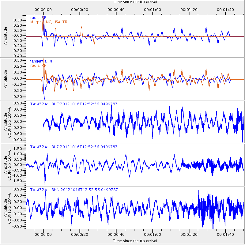
Signal To Noise
| Channel | StoN | STA | LTA |
| TA:W52A: :BHZ:20121016T12:52:56.049978Z | 3.0225203 | 5.6601846E-7 | 1.8726706E-7 |
| TA:W52A: :BHN:20121016T12:52:56.049978Z | 1.6000869 | 2.9677275E-7 | 1.854729E-7 |
| TA:W52A: :BHE:20121016T12:52:56.049978Z | 1.2401428 | 2.2959355E-7 | 1.8513477E-7 |
| Arrivals |
| Ps | |
| PpPs | |
| PsPs/PpSs | |


