You are here: Home > Network List > G - GEOSCOPE Stations List
> Station WUS Wushi, Xinjiang Uygur, China > Earthquake Result Viewer
WUS Wushi, Xinjiang Uygur, China - Earthquake Result Viewer
| Earthquake location: |
Fox Islands, Aleutian Islands |
| Earthquake latitude/longitude: |
52.9/-169.1 |
| Earthquake time(UTC): |
1999/01/28 (028) 08:10:05 GMT |
| Earthquake Depth: |
67 km |
| Earthquake Magnitude: |
6.3 MB, 6.1 MS, 6.6 MW, 6.6 ME |
| Earthquake Catalog/Contributor: |
WHDF/NEIC |
|
| Network: |
G GEOSCOPE |
| Station: |
WUS Wushi, Xinjiang Uygur, China |
| Lat/Lon: |
41.20 N/79.22 E |
| Elevation: |
1457 m |
|
| Distance: |
69.3 deg |
| Az: |
311.44 deg |
| Baz: |
37.013 deg |
| Ray Param: |
0.055574626 |
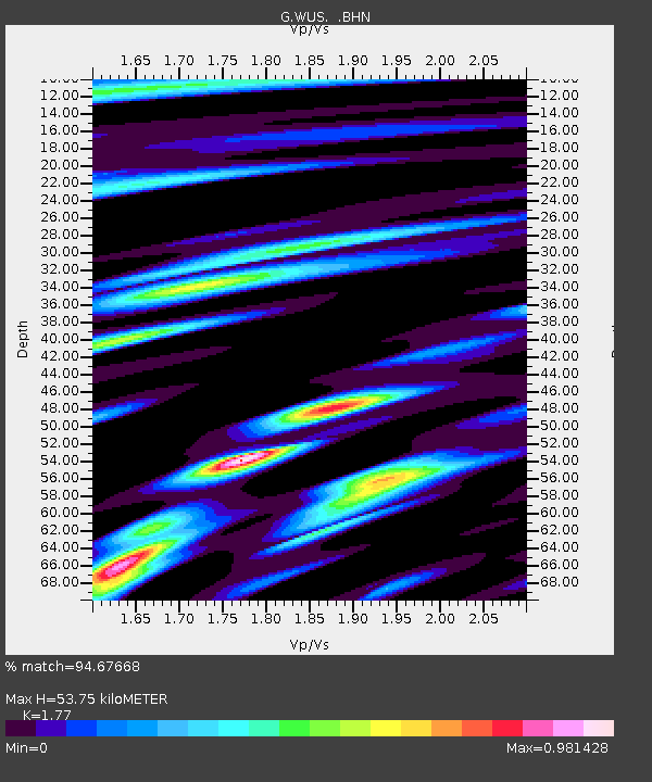
| Estimated Moho Depth: |
53.75 km |
| Estimated Crust Vp/Vs: |
1.77 |
| Assumed Crust Vp: |
6.353 km/s |
| Estimated Crust Vs: |
3.589 km/s |
| Estimated Crust Poisson's Ratio: |
0.27 |
|
| Radial Match: |
94.67668 % |
| Radial Bump: |
400 |
| Transverse Match: |
89.11894 % |
| Transverse Bump: |
400 |
| SOD ConfigId: |
4480 |
| Insert Time: |
2010-02-27 01:01:13.785 +0000 |
| GWidth: |
2.5 |
| Max Bumps: |
400 |
| Tol: |
0.001 |
|

Signal To Noise
| Channel | StoN | STA | LTA |
| G:WUS: :BHN:19990128T08:20:34.839006Z | 22.849401 | 1.0696627E-6 | 4.68136E-8 |
| G:WUS: :BHE:19990128T08:20:34.839006Z | 6.5484734 | 2.96753E-7 | 4.5316366E-8 |
| G:WUS: :BHZ:19990128T08:20:34.839006Z | 9.240948 | 2.8673742E-7 | 3.1029003E-8 |
| Arrivals |
| Ps | 6.8 SECOND |
| PpPs | 23 SECOND |
| PsPs/PpSs | 29 SECOND |


