You are here: Home > Network List > G - GEOSCOPE Stations List
> Station WUS Wushi, Xinjiang Uygur, China > Earthquake Result Viewer
WUS Wushi, Xinjiang Uygur, China - Earthquake Result Viewer

| Earthquake location: |
Solomon Islands |
| Earthquake latitude/longitude: |
-8.6/156.6 |
| Earthquake time(UTC): |
1995/04/17 (107) 01:14:20 GMT |
| Earthquake Depth: |
36 km |
| Earthquake Magnitude: |
5.8 MB, 6.0 MS, 5.9 UNKNOWN, 6.1 MW |
| Earthquake Catalog/Contributor: |
WHDF/NEIC |
|
| Network: |
G GEOSCOPE |
| Station: |
WUS Wushi, Xinjiang Uygur, China |
| Lat/Lon: |
41.20 N/79.22 E |
| Elevation: |
1457 m |
|
| Distance: |
86.2 deg |
| Az: |
312.438 deg |
| Baz: |
104.718 deg |
| Ray Param: |
0.044142947 |
| Estimated Moho Depth: |
48.5 km |
| Estimated Crust Vp/Vs: |
1.85 |
| Assumed Crust Vp: |
6.353 km/s |
| Estimated Crust Vs: |
3.443 km/s |
| Estimated Crust Poisson's Ratio: |
0.29 |
|
| Radial Match: |
94.355934 % |
| Radial Bump: |
321 |
| Transverse Match: |
84.041725 % |
| Transverse Bump: |
400 |
| SOD ConfigId: |
4480 |
| Insert Time: |
2010-02-27 01:01:19.136 +0000 |
| GWidth: |
2.5 |
| Max Bumps: |
400 |
| Tol: |
0.001 |
|
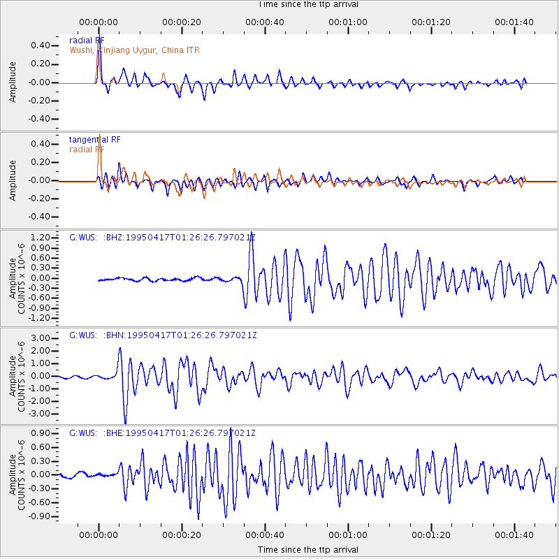
Signal To Noise
| Channel | StoN | STA | LTA |
| G:WUS: :BHN:19950417T01:26:26.797021Z | 7.470917 | 4.3729187E-7 | 5.853256E-8 |
| G:WUS: :BHE:19950417T01:26:26.797021Z | 0.7429449 | 3.6737113E-8 | 4.9447966E-8 |
| G:WUS: :BHZ:19950417T01:26:26.797021Z | 2.0777824 | 8.523181E-8 | 4.102057E-8 |
| Arrivals |
| Ps | 6.6 SECOND |
| PpPs | 21 SECOND |
| PsPs/PpSs | 28 SECOND |


