You are here: Home > Network List > TA - USArray Transportable Network (new EarthScope stations) Stations List
> Station O03E Paynes Creek, CA, USA > Earthquake Result Viewer
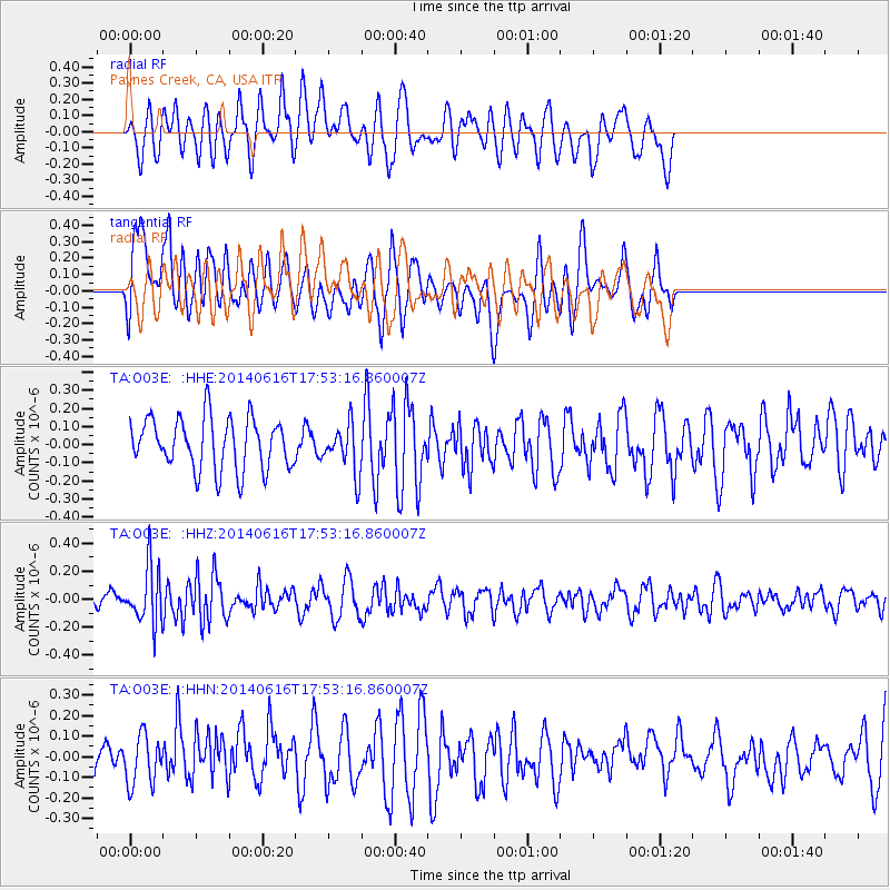
O03E Paynes Creek, CA, USA - Earthquake Result Viewer
*The percent match for this event was below the threshold and hence no stack was calculated.
| Earthquake location: |
Southeast Of Honshu, Japan |
| Earthquake latitude/longitude: |
33.9/139.7 |
| Earthquake time(UTC): |
2014/06/16 (167) 17:42:22 GMT |
| Earthquake Depth: |
132 km |
| Earthquake Magnitude: |
5.3 MW |
| Earthquake Catalog/Contributor: |
ISC/ISC |
|
| Network: |
TA USArray Transportable Network (new EarthScope stations) |
| Station: |
O03E Paynes Creek, CA, USA |
| Lat/Lon: |
40.29 N/121.80 W |
| Elevation: |
967 m |
|
| Distance: |
74.7 deg |
| Az: |
51.639 deg |
| Baz: |
301.541 deg |
| Ray Param: |
$rayparam |
*The percent match for this event was below the threshold and hence was not used in the summary stack. |
|
| Radial Match: |
48.979 % |
| Radial Bump: |
400 |
| Transverse Match: |
51.587994 % |
| Transverse Bump: |
400 |
| SOD ConfigId: |
3390531 |
| Insert Time: |
2019-04-12 08:06:16.776 +0000 |
| GWidth: |
2.5 |
| Max Bumps: |
400 |
| Tol: |
0.001 |
|
Signal To Noise
| Channel | StoN | STA | LTA |
| TA:O03E: :HHZ:20140616T17:53:16.860007Z | 3.3418934 | 2.0347657E-7 | 6.088661E-8 |
| TA:O03E: :HHN:20140616T17:53:16.860007Z | 0.98529005 | 1.1734489E-7 | 1.19096796E-7 |
| TA:O03E: :HHE:20140616T17:53:16.860007Z | 0.9437287 | 1.3363889E-7 | 1.4160733E-7 |
| Arrivals |
| Ps | |
| PpPs | |
| PsPs/PpSs | |


