You are here: Home > Network List > TA - USArray Transportable Network (new EarthScope stations) Stations List
> Station E54A Lac Daplat, Pontiac, MRC, QC, CAN > Earthquake Result Viewer
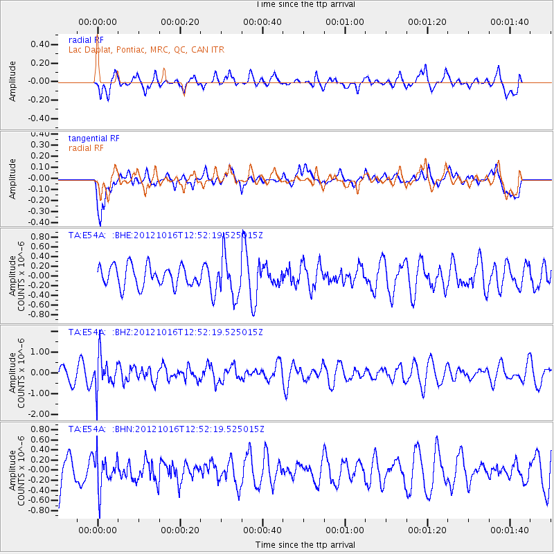
E54A Lac Daplat, Pontiac, MRC, QC, CAN - Earthquake Result Viewer
*The percent match for this event was below the threshold and hence no stack was calculated.
| Earthquake location: |
Kuril Islands |
| Earthquake latitude/longitude: |
49.6/156.4 |
| Earthquake time(UTC): |
2012/10/16 (290) 12:41:25 GMT |
| Earthquake Depth: |
81 km |
| Earthquake Magnitude: |
6.2 MB, 5.6 MW, 5.6 MW |
| Earthquake Catalog/Contributor: |
WHDF/NEIC |
|
| Network: |
TA USArray Transportable Network (new EarthScope stations) |
| Station: |
E54A Lac Daplat, Pontiac, MRC, QC, CAN |
| Lat/Lon: |
46.43 N/77.19 W |
| Elevation: |
277 m |
|
| Distance: |
73.6 deg |
| Az: |
35.478 deg |
| Baz: |
326.921 deg |
| Ray Param: |
$rayparam |
*The percent match for this event was below the threshold and hence was not used in the summary stack. |
|
| Radial Match: |
44.48021 % |
| Radial Bump: |
400 |
| Transverse Match: |
68.2097 % |
| Transverse Bump: |
400 |
| SOD ConfigId: |
478790 |
| Insert Time: |
2013-02-23 10:17:20.001 +0000 |
| GWidth: |
2.5 |
| Max Bumps: |
400 |
| Tol: |
0.001 |
|
Signal To Noise
| Channel | StoN | STA | LTA |
| TA:E54A: :BHZ:20121016T12:52:19.525015Z | 2.2336733 | 7.870519E-7 | 3.5235763E-7 |
| TA:E54A: :BHN:20121016T12:52:19.525015Z | 0.97665626 | 3.2437862E-7 | 3.3213183E-7 |
| TA:E54A: :BHE:20121016T12:52:19.525015Z | 1.9470084 | 4.1028434E-7 | 2.1072552E-7 |
| Arrivals |
| Ps | |
| PpPs | |
| PsPs/PpSs | |


