You are here: Home > Network List > TA - USArray Transportable Network (new EarthScope stations) Stations List
> Station J45A Montague, MI, USA > Earthquake Result Viewer
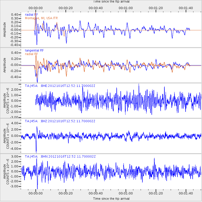
J45A Montague, MI, USA - Earthquake Result Viewer
*The percent match for this event was below the threshold and hence no stack was calculated.
| Earthquake location: |
Kuril Islands |
| Earthquake latitude/longitude: |
49.6/156.4 |
| Earthquake time(UTC): |
2012/10/16 (290) 12:41:25 GMT |
| Earthquake Depth: |
81 km |
| Earthquake Magnitude: |
6.2 MB, 5.6 MW, 5.6 MW |
| Earthquake Catalog/Contributor: |
WHDF/NEIC |
|
| Network: |
TA USArray Transportable Network (new EarthScope stations) |
| Station: |
J45A Montague, MI, USA |
| Lat/Lon: |
43.44 N/86.39 W |
| Elevation: |
209 m |
|
| Distance: |
72.3 deg |
| Az: |
42.863 deg |
| Baz: |
322.6 deg |
| Ray Param: |
$rayparam |
*The percent match for this event was below the threshold and hence was not used in the summary stack. |
|
| Radial Match: |
57.76994 % |
| Radial Bump: |
400 |
| Transverse Match: |
62.28311 % |
| Transverse Bump: |
400 |
| SOD ConfigId: |
478790 |
| Insert Time: |
2013-02-23 10:18:22.509 +0000 |
| GWidth: |
2.5 |
| Max Bumps: |
400 |
| Tol: |
0.001 |
|
Signal To Noise
| Channel | StoN | STA | LTA |
| TA:J45A: :BHZ:20121016T12:52:11.700002Z | 3.0745773 | 1.4387685E-6 | 4.679565E-7 |
| TA:J45A: :BHN:20121016T12:52:11.700002Z | 2.254675 | 1.2210628E-6 | 5.415693E-7 |
| TA:J45A: :BHE:20121016T12:52:11.700002Z | 1.630797 | 1.1135634E-6 | 6.8283384E-7 |
| Arrivals |
| Ps | |
| PpPs | |
| PsPs/PpSs | |


