You are here: Home > Network List > TA - USArray Transportable Network (new EarthScope stations) Stations List
> Station O03E Paynes Creek, CA, USA > Earthquake Result Viewer
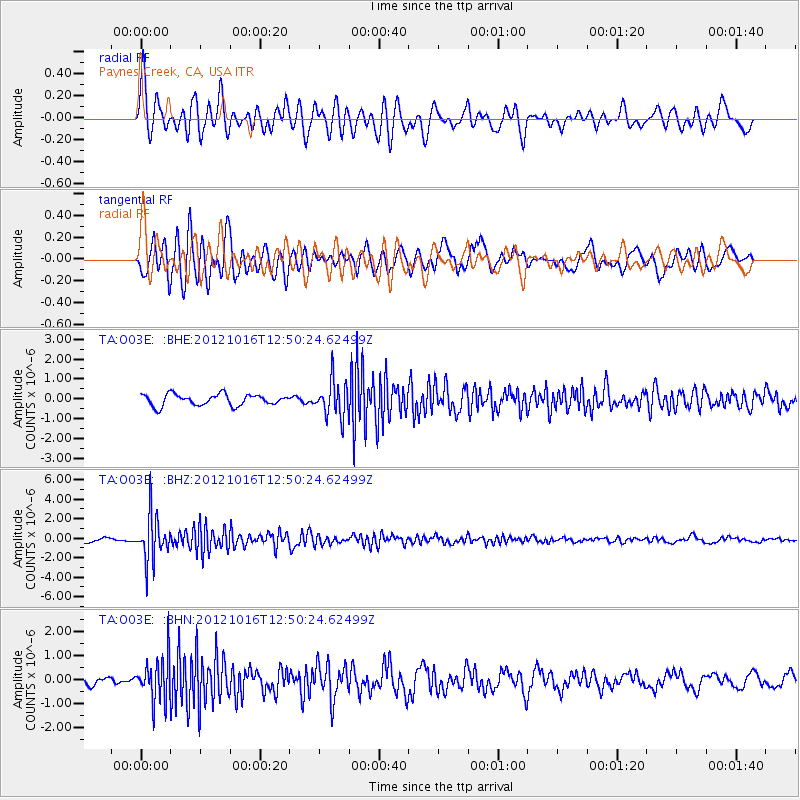
O03E Paynes Creek, CA, USA - Earthquake Result Viewer
*The percent match for this event was below the threshold and hence no stack was calculated.
| Earthquake location: |
Kuril Islands |
| Earthquake latitude/longitude: |
49.6/156.4 |
| Earthquake time(UTC): |
2012/10/16 (290) 12:41:25 GMT |
| Earthquake Depth: |
81 km |
| Earthquake Magnitude: |
6.2 MB, 5.6 MW, 5.6 MW |
| Earthquake Catalog/Contributor: |
WHDF/NEIC |
|
| Network: |
TA USArray Transportable Network (new EarthScope stations) |
| Station: |
O03E Paynes Creek, CA, USA |
| Lat/Lon: |
40.29 N/121.80 W |
| Elevation: |
967 m |
|
| Distance: |
55.9 deg |
| Az: |
66.083 deg |
| Baz: |
308.983 deg |
| Ray Param: |
$rayparam |
*The percent match for this event was below the threshold and hence was not used in the summary stack. |
|
| Radial Match: |
74.85265 % |
| Radial Bump: |
400 |
| Transverse Match: |
70.89668 % |
| Transverse Bump: |
400 |
| SOD ConfigId: |
478790 |
| Insert Time: |
2013-02-23 10:19:25.123 +0000 |
| GWidth: |
2.5 |
| Max Bumps: |
400 |
| Tol: |
0.001 |
|
Signal To Noise
| Channel | StoN | STA | LTA |
| TA:O03E: :BHZ:20121016T12:50:24.62499Z | 10.288626 | 2.3501352E-6 | 2.2842072E-7 |
| TA:O03E: :BHN:20121016T12:50:24.62499Z | 4.2823215 | 9.0817207E-7 | 2.1207472E-7 |
| TA:O03E: :BHE:20121016T12:50:24.62499Z | 3.154996 | 8.9296714E-7 | 2.8303273E-7 |
| Arrivals |
| Ps | |
| PpPs | |
| PsPs/PpSs | |


