You are here: Home > Network List > US - United States National Seismic Network Stations List
> Station DGMT Dagmar, Montana, USA > Earthquake Result Viewer
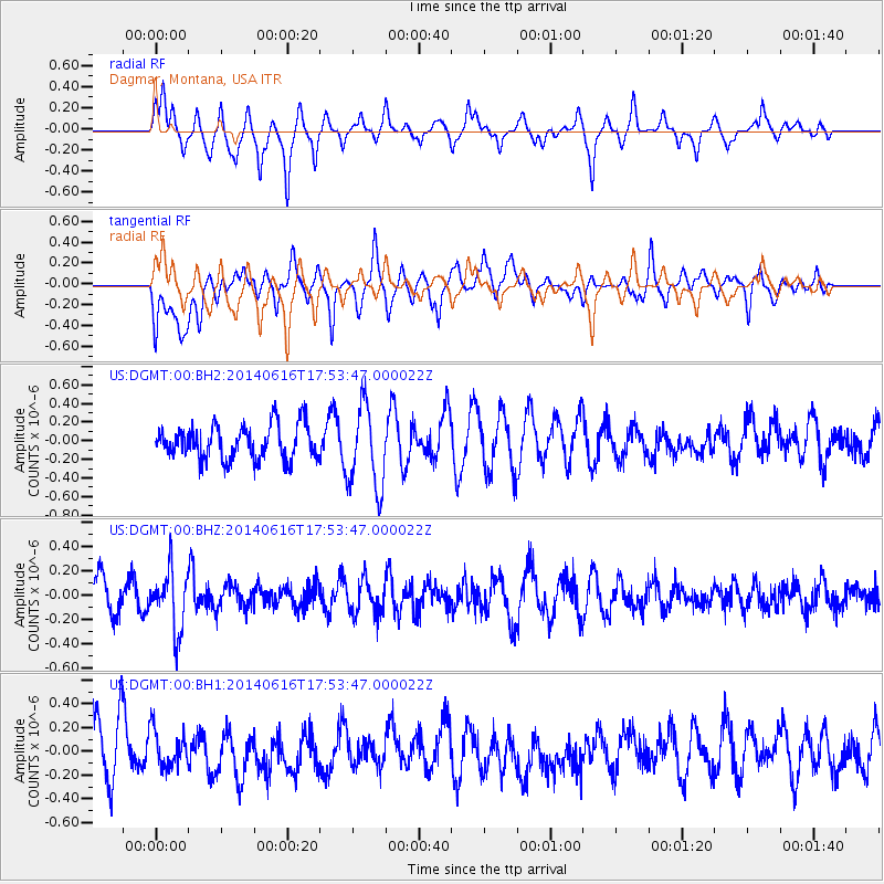
DGMT Dagmar, Montana, USA - Earthquake Result Viewer
*The percent match for this event was below the threshold and hence no stack was calculated.
| Earthquake location: |
Southeast Of Honshu, Japan |
| Earthquake latitude/longitude: |
33.9/139.7 |
| Earthquake time(UTC): |
2014/06/16 (167) 17:42:22 GMT |
| Earthquake Depth: |
132 km |
| Earthquake Magnitude: |
5.3 MW |
| Earthquake Catalog/Contributor: |
ISC/ISC |
|
| Network: |
US United States National Seismic Network |
| Station: |
DGMT Dagmar, Montana, USA |
| Lat/Lon: |
48.47 N/104.20 W |
| Elevation: |
0.0 m |
|
| Distance: |
80.2 deg |
| Az: |
37.325 deg |
| Baz: |
310.762 deg |
| Ray Param: |
$rayparam |
*The percent match for this event was below the threshold and hence was not used in the summary stack. |
|
| Radial Match: |
64.94506 % |
| Radial Bump: |
400 |
| Transverse Match: |
71.33982 % |
| Transverse Bump: |
400 |
| SOD ConfigId: |
3390531 |
| Insert Time: |
2019-04-12 08:06:48.909 +0000 |
| GWidth: |
2.5 |
| Max Bumps: |
400 |
| Tol: |
0.001 |
|
Signal To Noise
| Channel | StoN | STA | LTA |
| US:DGMT:00:BHZ:20140616T17:53:47.000022Z | 1.7313904 | 2.453416E-7 | 1.4170207E-7 |
| US:DGMT:00:BH1:20140616T17:53:47.000022Z | 0.8375472 | 1.5776556E-7 | 1.8836617E-7 |
| US:DGMT:00:BH2:20140616T17:53:47.000022Z | 2.4814246 | 4.493787E-7 | 1.8109706E-7 |
| Arrivals |
| Ps | |
| PpPs | |
| PsPs/PpSs | |


