You are here: Home > Network List > G - GEOSCOPE Stations List
> Station WUS Wushi, Xinjiang Uygur, China > Earthquake Result Viewer
WUS Wushi, Xinjiang Uygur, China - Earthquake Result Viewer
| Earthquake location: |
Santa Cruz Islands |
| Earthquake latitude/longitude: |
-12.9/166.7 |
| Earthquake time(UTC): |
1999/02/06 (037) 21:47:59 GMT |
| Earthquake Depth: |
90 km |
| Earthquake Magnitude: |
6.3 MB, 7.3 MS, 7.4 MW, 7.0 ME |
| Earthquake Catalog/Contributor: |
WHDF/NEIC |
|
| Network: |
G GEOSCOPE |
| Station: |
WUS Wushi, Xinjiang Uygur, China |
| Lat/Lon: |
41.20 N/79.22 E |
| Elevation: |
1457 m |
|
| Distance: |
96.5 deg |
| Az: |
310.649 deg |
| Baz: |
101.314 deg |
| Ray Param: |
0.040436257 |
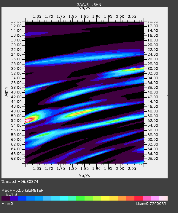
| Estimated Moho Depth: |
52.0 km |
| Estimated Crust Vp/Vs: |
1.60 |
| Assumed Crust Vp: |
6.353 km/s |
| Estimated Crust Vs: |
3.971 km/s |
| Estimated Crust Poisson's Ratio: |
0.18 |
|
| Radial Match: |
96.30374 % |
| Radial Bump: |
400 |
| Transverse Match: |
94.70013 % |
| Transverse Bump: |
400 |
| SOD ConfigId: |
4480 |
| Insert Time: |
2010-02-27 01:01:37.625 +0000 |
| GWidth: |
2.5 |
| Max Bumps: |
400 |
| Tol: |
0.001 |
|

Signal To Noise
| Channel | StoN | STA | LTA |
| G:WUS: :BHN:19990206T22:00:47.261016Z | 6.26314 | 7.02715E-7 | 1.12198514E-7 |
| G:WUS: :BHE:19990206T22:00:47.261016Z | 1.0692532 | 8.6045E-8 | 8.047205E-8 |
| G:WUS: :BHZ:19990206T22:00:47.261016Z | 2.9767165 | 2.127451E-7 | 7.146972E-8 |
| Arrivals |
| Ps | 5.0 SECOND |
| PpPs | 21 SECOND |
| PsPs/PpSs | 26 SECOND |


