You are here: Home > Network List > UW - Pacific Northwest Regional Seismic Network Stations List
> Station OMAK Colville Reservation, Omak, WA, USA > Earthquake Result Viewer
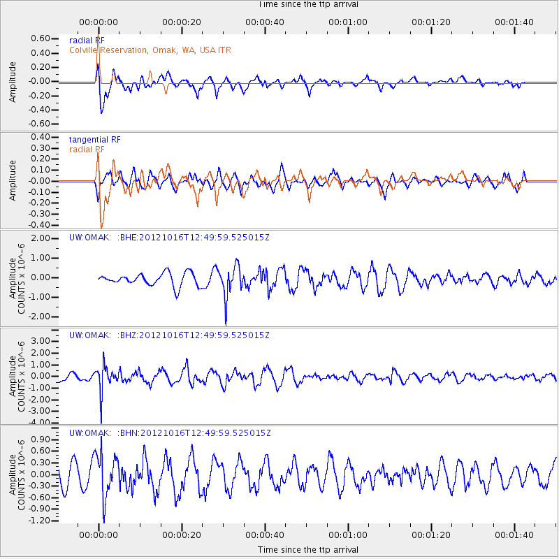
OMAK Colville Reservation, Omak, WA, USA - Earthquake Result Viewer
*The percent match for this event was below the threshold and hence no stack was calculated.
| Earthquake location: |
Kuril Islands |
| Earthquake latitude/longitude: |
49.6/156.4 |
| Earthquake time(UTC): |
2012/10/16 (290) 12:41:25 GMT |
| Earthquake Depth: |
81 km |
| Earthquake Magnitude: |
6.2 MB, 5.6 MW, 5.6 MW |
| Earthquake Catalog/Contributor: |
WHDF/NEIC |
|
| Network: |
UW Pacific Northwest Regional Seismic Network |
| Station: |
OMAK Colville Reservation, Omak, WA, USA |
| Lat/Lon: |
48.36 N/119.33 W |
| Elevation: |
696 m |
|
| Distance: |
52.4 deg |
| Az: |
56.834 deg |
| Baz: |
305.283 deg |
| Ray Param: |
$rayparam |
*The percent match for this event was below the threshold and hence was not used in the summary stack. |
|
| Radial Match: |
80.754295 % |
| Radial Bump: |
400 |
| Transverse Match: |
47.532475 % |
| Transverse Bump: |
400 |
| SOD ConfigId: |
478790 |
| Insert Time: |
2013-02-23 10:22:41.982 +0000 |
| GWidth: |
2.5 |
| Max Bumps: |
400 |
| Tol: |
0.001 |
|
Signal To Noise
| Channel | StoN | STA | LTA |
| UW:OMAK: :BHZ:20121016T12:49:59.525015Z | 3.8320074 | 1.0717725E-6 | 2.796896E-7 |
| UW:OMAK: :BHN:20121016T12:49:59.525015Z | 2.317262 | 5.5286233E-7 | 2.385843E-7 |
| UW:OMAK: :BHE:20121016T12:49:59.525015Z | 2.3989654 | 7.6558405E-7 | 3.1913092E-7 |
| Arrivals |
| Ps | |
| PpPs | |
| PsPs/PpSs | |


