You are here: Home > Network List > US - United States National Seismic Network Stations List
> Station MSO Missoula, Montana, USA > Earthquake Result Viewer
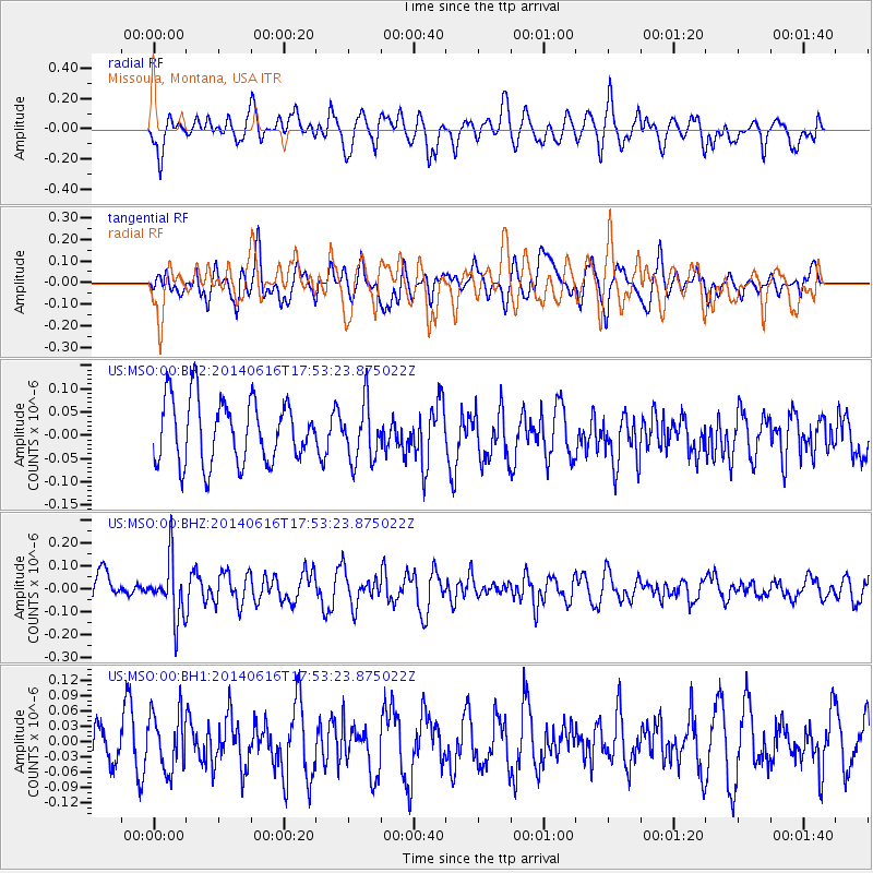
MSO Missoula, Montana, USA - Earthquake Result Viewer
*The percent match for this event was below the threshold and hence no stack was calculated.
| Earthquake location: |
Southeast Of Honshu, Japan |
| Earthquake latitude/longitude: |
33.9/139.7 |
| Earthquake time(UTC): |
2014/06/16 (167) 17:42:22 GMT |
| Earthquake Depth: |
132 km |
| Earthquake Magnitude: |
5.3 MW |
| Earthquake Catalog/Contributor: |
ISC/ISC |
|
| Network: |
US United States National Seismic Network |
| Station: |
MSO Missoula, Montana, USA |
| Lat/Lon: |
46.83 N/113.94 W |
| Elevation: |
1264 m |
|
| Distance: |
75.9 deg |
| Az: |
42.766 deg |
| Baz: |
304.702 deg |
| Ray Param: |
$rayparam |
*The percent match for this event was below the threshold and hence was not used in the summary stack. |
|
| Radial Match: |
67.84555 % |
| Radial Bump: |
400 |
| Transverse Match: |
67.63993 % |
| Transverse Bump: |
400 |
| SOD ConfigId: |
3390531 |
| Insert Time: |
2019-04-12 08:06:54.972 +0000 |
| GWidth: |
2.5 |
| Max Bumps: |
400 |
| Tol: |
0.001 |
|
Signal To Noise
| Channel | StoN | STA | LTA |
| US:MSO:00:BHZ:20140616T17:53:23.875022Z | 2.3765545 | 1.269248E-7 | 5.340707E-8 |
| US:MSO:00:BH1:20140616T17:53:23.875022Z | 1.7750658 | 5.518751E-8 | 3.10904E-8 |
| US:MSO:00:BH2:20140616T17:53:23.875022Z | 0.9180276 | 6.213823E-8 | 6.768667E-8 |
| Arrivals |
| Ps | |
| PpPs | |
| PsPs/PpSs | |


