You are here: Home > Network List > G - GEOSCOPE Stations List
> Station WUS Wushi, Xinjiang Uygur, China > Earthquake Result Viewer
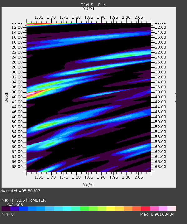
WUS Wushi, Xinjiang Uygur, China - Earthquake Result Viewer
| Earthquake location: |
Near East Coast Of Honshu, Japan |
| Earthquake latitude/longitude: |
35.6/141.8 |
| Earthquake time(UTC): |
1999/03/02 (061) 07:12:20 GMT |
| Earthquake Depth: |
33 km |
| Earthquake Magnitude: |
5.6 MS, 5.4 MB, 6.1 MW, 6.0 MW |
| Earthquake Catalog/Contributor: |
WHDF/NEIC |
|
| Network: |
G GEOSCOPE |
| Station: |
WUS Wushi, Xinjiang Uygur, China |
| Lat/Lon: |
41.20 N/79.22 E |
| Elevation: |
1457 m |
|
| Distance: |
48.4 deg |
| Az: |
296.452 deg |
| Baz: |
75.236 deg |
| Ray Param: |
0.06931873 |
| Estimated Moho Depth: |
38.5 km |
| Estimated Crust Vp/Vs: |
1.61 |
| Assumed Crust Vp: |
6.353 km/s |
| Estimated Crust Vs: |
3.958 km/s |
| Estimated Crust Poisson's Ratio: |
0.18 |
|
| Radial Match: |
95.50687 % |
| Radial Bump: |
396 |
| Transverse Match: |
87.5848 % |
| Transverse Bump: |
400 |
| SOD ConfigId: |
4480 |
| Insert Time: |
2010-02-27 01:01:58.049 +0000 |
| GWidth: |
2.5 |
| Max Bumps: |
400 |
| Tol: |
0.001 |
|

Signal To Noise
| Channel | StoN | STA | LTA |
| G:WUS: :BHN:19990302T07:20:29.100007Z | 14.154874 | 7.100987E-7 | 5.0166374E-8 |
| G:WUS: :BHE:19990302T07:20:29.100007Z | 3.4252145 | 1.1587613E-7 | 3.3830325E-8 |
| G:WUS: :BHZ:19990302T07:20:29.100007Z | 8.896912 | 3.3963076E-7 | 3.8174008E-8 |
| Arrivals |
| Ps | 3.9 SECOND |
| PpPs | 15 SECOND |
| PsPs/PpSs | 19 SECOND |


