You are here: Home > Network List > CN - Canadian National Seismograph Network Stations List
> Station INK INUVIK, NT > Earthquake Result Viewer
INK INUVIK, NT - Earthquake Result Viewer
*The percent match for this event was below the threshold and hence no stack was calculated.
| Earthquake location: |
Tonga Islands |
| Earthquake latitude/longitude: |
-19.0/-174.2 |
| Earthquake time(UTC): |
2012/10/17 (291) 17:23:42 GMT |
| Earthquake Depth: |
35 km |
| Earthquake Magnitude: |
5.5 MB, 5.0 MS, 5.4 MW |
| Earthquake Catalog/Contributor: |
WHDF/NEIC |
|
| Network: |
CN Canadian National Seismograph Network |
| Station: |
INK INUVIK, NT |
| Lat/Lon: |
68.31 N/133.53 W |
| Elevation: |
44 m |
|
| Distance: |
92.0 deg |
| Az: |
14.028 deg |
| Baz: |
218.078 deg |
| Ray Param: |
$rayparam |
*The percent match for this event was below the threshold and hence was not used in the summary stack. |
|
| Radial Match: |
62.30992 % |
| Radial Bump: |
400 |
| Transverse Match: |
78.50288 % |
| Transverse Bump: |
400 |
| SOD ConfigId: |
478790 |
| Insert Time: |
2013-02-23 15:32:16.684 +0000 |
| GWidth: |
2.5 |
| Max Bumps: |
400 |
| Tol: |
0.001 |
|
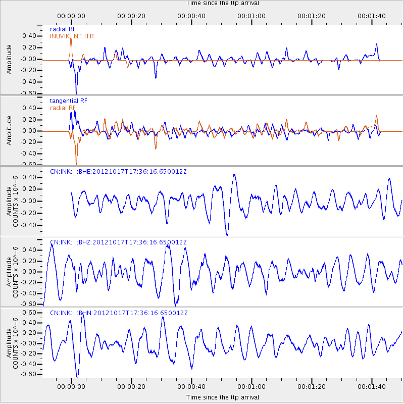
Signal To Noise
| Channel | StoN | STA | LTA |
| CN:INK: :BHZ:20121017T17:36:16.650012Z | 0.6862885 | 1.9391335E-7 | 2.8255369E-7 |
| CN:INK: :BHN:20121017T17:36:16.650012Z | 1.9324155 | 4.2460468E-7 | 2.1972741E-7 |
| CN:INK: :BHE:20121017T17:36:16.650012Z | 1.5333987 | 1.5612355E-7 | 1.0181537E-7 |
| Arrivals |
| Ps | |
| PpPs | |
| PsPs/PpSs | |


