You are here: Home > Network List > TA - USArray Transportable Network (new EarthScope stations) Stations List
> Station L39A Vinton, IA, USA > Earthquake Result Viewer
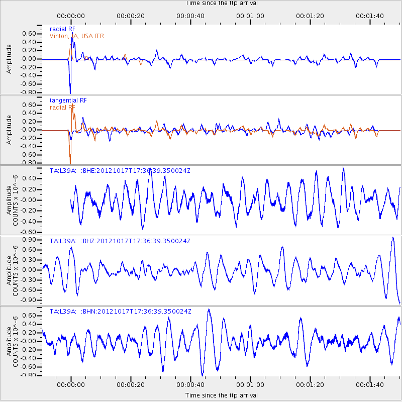
L39A Vinton, IA, USA - Earthquake Result Viewer
*The percent match for this event was below the threshold and hence no stack was calculated.
| Earthquake location: |
Tonga Islands |
| Earthquake latitude/longitude: |
-19.0/-174.2 |
| Earthquake time(UTC): |
2012/10/17 (291) 17:23:42 GMT |
| Earthquake Depth: |
35 km |
| Earthquake Magnitude: |
5.5 MB, 5.0 MS, 5.4 MW |
| Earthquake Catalog/Contributor: |
WHDF/NEIC |
|
| Network: |
TA USArray Transportable Network (new EarthScope stations) |
| Station: |
L39A Vinton, IA, USA |
| Lat/Lon: |
42.12 N/92.00 W |
| Elevation: |
261 m |
|
| Distance: |
97.0 deg |
| Az: |
47.944 deg |
| Baz: |
250.754 deg |
| Ray Param: |
$rayparam |
*The percent match for this event was below the threshold and hence was not used in the summary stack. |
|
| Radial Match: |
68.606964 % |
| Radial Bump: |
400 |
| Transverse Match: |
44.246723 % |
| Transverse Bump: |
400 |
| SOD ConfigId: |
478790 |
| Insert Time: |
2013-02-23 15:38:57.616 +0000 |
| GWidth: |
2.5 |
| Max Bumps: |
400 |
| Tol: |
0.001 |
|
Signal To Noise
| Channel | StoN | STA | LTA |
| TA:L39A: :BHZ:20121017T17:36:39.350024Z | 2.2968342 | 4.250222E-7 | 1.8504697E-7 |
| TA:L39A: :BHN:20121017T17:36:39.350024Z | 0.8068536 | 2.3131362E-7 | 2.86686E-7 |
| TA:L39A: :BHE:20121017T17:36:39.350024Z | 1.1218145 | 2.287543E-7 | 2.0391455E-7 |
| Arrivals |
| Ps | |
| PpPs | |
| PsPs/PpSs | |


