You are here: Home > Network List > UW - Pacific Northwest Regional Seismic Network Stations List
> Station PASS Maple Falls, WA, USA > Earthquake Result Viewer
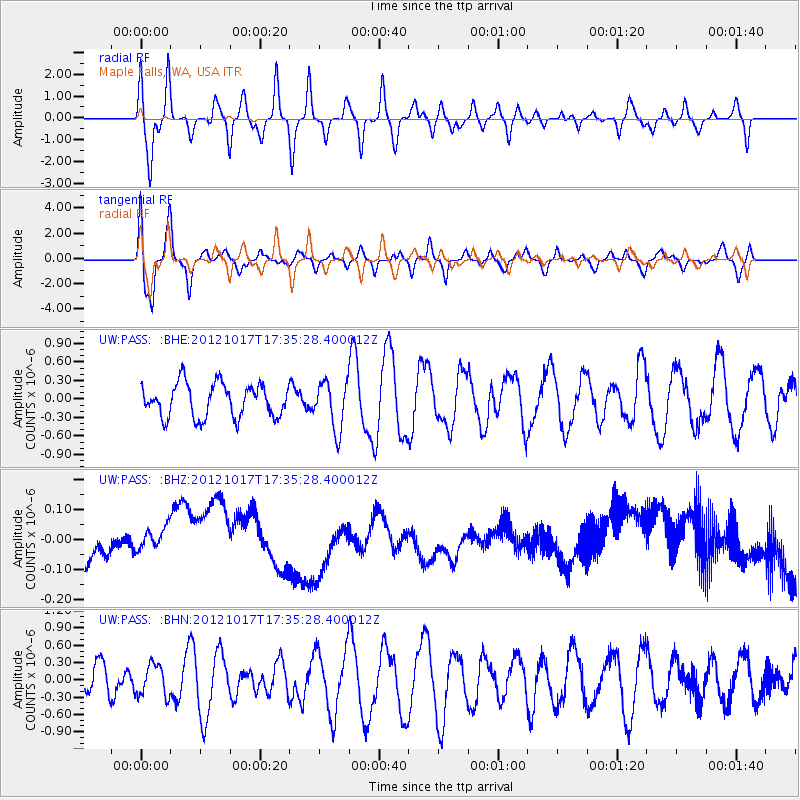
PASS Maple Falls, WA, USA - Earthquake Result Viewer
*The percent match for this event was below the threshold and hence no stack was calculated.
| Earthquake location: |
Tonga Islands |
| Earthquake latitude/longitude: |
-19.0/-174.2 |
| Earthquake time(UTC): |
2012/10/17 (291) 17:23:42 GMT |
| Earthquake Depth: |
35 km |
| Earthquake Magnitude: |
5.5 MB, 5.0 MS, 5.4 MW |
| Earthquake Catalog/Contributor: |
WHDF/NEIC |
|
| Network: |
UW Pacific Northwest Regional Seismic Network |
| Station: |
PASS Maple Falls, WA, USA |
| Lat/Lon: |
49.00 N/122.09 W |
| Elevation: |
174 m |
|
| Distance: |
82.0 deg |
| Az: |
31.652 deg |
| Baz: |
228.915 deg |
| Ray Param: |
$rayparam |
*The percent match for this event was below the threshold and hence was not used in the summary stack. |
|
| Radial Match: |
63.990097 % |
| Radial Bump: |
400 |
| Transverse Match: |
67.60794 % |
| Transverse Bump: |
400 |
| SOD ConfigId: |
478790 |
| Insert Time: |
2013-02-23 15:41:04.220 +0000 |
| GWidth: |
2.5 |
| Max Bumps: |
400 |
| Tol: |
0.001 |
|
Signal To Noise
| Channel | StoN | STA | LTA |
| UW:PASS: :BHZ:20121017T17:35:28.400012Z | 0.6688794 | 4.70084E-8 | 7.0279334E-8 |
| UW:PASS: :BHN:20121017T17:35:28.400012Z | 0.9974111 | 2.7315903E-7 | 2.7386804E-7 |
| UW:PASS: :BHE:20121017T17:35:28.400012Z | 1.4575266 | 3.9108826E-7 | 2.6832325E-7 |
| Arrivals |
| Ps | |
| PpPs | |
| PsPs/PpSs | |


