You are here: Home > Network List > AU - Australian Seismological Centre Stations List
> Station MTN Manton Dam, Northern Territory > Earthquake Result Viewer
MTN Manton Dam, Northern Territory - Earthquake Result Viewer
| Earthquake location: |
West Of Macquarie Island |
| Earthquake latitude/longitude: |
-54.2/144.0 |
| Earthquake time(UTC): |
2012/10/18 (292) 01:27:16 GMT |
| Earthquake Depth: |
7.5 km |
| Earthquake Magnitude: |
5.6 MB, 5.8 MS, 5.9 MW, 5.9 MW |
| Earthquake Catalog/Contributor: |
WHDF/NEIC |
|
| Network: |
AU Australian Seismological Centre |
| Station: |
MTN Manton Dam, Northern Territory |
| Lat/Lon: |
12.84 S/131.13 E |
| Elevation: |
137 m |
|
| Distance: |
42.5 deg |
| Az: |
341.242 deg |
| Baz: |
168.834 deg |
| Ray Param: |
0.07313985 |
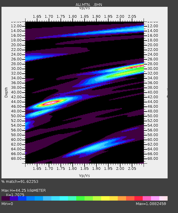
| Estimated Moho Depth: |
44.25 km |
| Estimated Crust Vp/Vs: |
1.71 |
| Assumed Crust Vp: |
6.61 km/s |
| Estimated Crust Vs: |
3.871 km/s |
| Estimated Crust Poisson's Ratio: |
0.24 |
|
| Radial Match: |
91.62253 % |
| Radial Bump: |
325 |
| Transverse Match: |
65.26825 % |
| Transverse Bump: |
400 |
| SOD ConfigId: |
478790 |
| Insert Time: |
2013-02-23 15:43:22.937 +0000 |
| GWidth: |
2.5 |
| Max Bumps: |
400 |
| Tol: |
0.001 |
|

Signal To Noise
| Channel | StoN | STA | LTA |
| AU:MTN: :BHZ:20121018T01:34:40.970012Z | 4.547294 | 7.3104036E-7 | 1.607638E-7 |
| AU:MTN: :BHN:20121018T01:34:40.970012Z | 3.6055467 | 4.184659E-7 | 1.16061706E-7 |
| AU:MTN: :BHE:20121018T01:34:40.970012Z | 1.1321098 | 2.2419252E-7 | 1.9803075E-7 |
| Arrivals |
| Ps | 5.1 SECOND |
| PpPs | 17 SECOND |
| PsPs/PpSs | 22 SECOND |


