You are here: Home > Network List > G - GEOSCOPE Stations List
> Station WUS Wushi, Xinjiang Uygur, China > Earthquake Result Viewer
WUS Wushi, Xinjiang Uygur, China - Earthquake Result Viewer
| Earthquake location: |
Southwestern Ryukyu Isl., Japan |
| Earthquake latitude/longitude: |
23.3/124.2 |
| Earthquake time(UTC): |
2000/11/08 (313) 18:36:21 GMT |
| Earthquake Depth: |
14 km |
| Earthquake Magnitude: |
5.7 MB, 5.5 MS, 5.8 MW, 5.6 MW |
| Earthquake Catalog/Contributor: |
WHDF/NEIC |
|
| Network: |
G GEOSCOPE |
| Station: |
WUS Wushi, Xinjiang Uygur, China |
| Lat/Lon: |
41.20 N/79.22 E |
| Elevation: |
1457 m |
|
| Distance: |
41.5 deg |
| Az: |
306.461 deg |
| Baz: |
101.406 deg |
| Ray Param: |
0.073738836 |
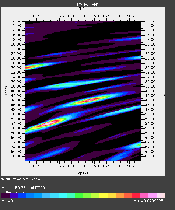
| Estimated Moho Depth: |
53.75 km |
| Estimated Crust Vp/Vs: |
1.70 |
| Assumed Crust Vp: |
6.353 km/s |
| Estimated Crust Vs: |
3.743 km/s |
| Estimated Crust Poisson's Ratio: |
0.23 |
|
| Radial Match: |
95.516754 % |
| Radial Bump: |
400 |
| Transverse Match: |
86.89047 % |
| Transverse Bump: |
400 |
| SOD ConfigId: |
3753 |
| Insert Time: |
2010-02-27 01:02:18.190 +0000 |
| GWidth: |
2.5 |
| Max Bumps: |
400 |
| Tol: |
0.001 |
|

Signal To Noise
| Channel | StoN | STA | LTA |
| G:WUS: :BHN:20001108T18:43:37.400012Z | 7.4652066 | 3.354618E-7 | 4.493671E-8 |
| G:WUS: :BHE:20001108T18:43:37.400012Z | 23.364769 | 1.2659825E-6 | 5.4183392E-8 |
| G:WUS: :BHZ:20001108T18:43:37.400012Z | 27.753784 | 2.0974853E-6 | 7.5574754E-8 |
| Arrivals |
| Ps | 6.3 SECOND |
| PpPs | 21 SECOND |
| PsPs/PpSs | 28 SECOND |


