You are here: Home > Network List > IC - New China Digital Seismograph Network Stations List
> Station WMQ Urumqi, Xinjiang Province, China > Earthquake Result Viewer
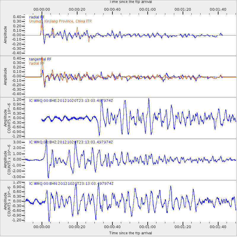
WMQ Urumqi, Xinjiang Province, China - Earthquake Result Viewer

| Earthquake location: |
Vanuatu Islands |
| Earthquake latitude/longitude: |
-13.6/166.6 |
| Earthquake time(UTC): |
2012/10/20 (294) 23:00:32 GMT |
| Earthquake Depth: |
36 km |
| Earthquake Magnitude: |
5.9 MB, 6.1 MS, 6.2 MW, 6.2 MW |
| Earthquake Catalog/Contributor: |
WHDF/NEIC |
|
| Network: |
IC New China Digital Seismograph Network |
| Station: |
WMQ Urumqi, Xinjiang Province, China |
| Lat/Lon: |
43.81 N/87.70 E |
| Elevation: |
850 m |
|
| Distance: |
91.4 deg |
| Az: |
314.726 deg |
| Baz: |
107.355 deg |
| Ray Param: |
0.04159949 |
| Estimated Moho Depth: |
22.0 km |
| Estimated Crust Vp/Vs: |
2.06 |
| Assumed Crust Vp: |
6.242 km/s |
| Estimated Crust Vs: |
3.034 km/s |
| Estimated Crust Poisson's Ratio: |
0.35 |
|
| Radial Match: |
95.57272 % |
| Radial Bump: |
400 |
| Transverse Match: |
92.88311 % |
| Transverse Bump: |
400 |
| SOD ConfigId: |
478790 |
| Insert Time: |
2013-02-23 16:01:36.430 +0000 |
| GWidth: |
2.5 |
| Max Bumps: |
400 |
| Tol: |
0.001 |
|
Signal To Noise
| Channel | StoN | STA | LTA |
| IC:WMQ:00:BHZ:20121020T23:13:03.497974Z | 30.569283 | 1.6374505E-6 | 5.3565227E-8 |
| IC:WMQ:00:BHN:20121020T23:13:03.497974Z | 6.0769954 | 4.886615E-7 | 8.041169E-8 |
| IC:WMQ:00:BHE:20121020T23:13:03.497974Z | 6.956265 | 5.933116E-7 | 8.529169E-8 |
| Arrivals |
| Ps | 3.8 SECOND |
| PpPs | 11 SECOND |
| PsPs/PpSs | 14 SECOND |


