You are here: Home > Network List > TA - USArray Transportable Network (new EarthScope stations) Stations List
> Station TPFO Pinon Flats, CA, USA > Earthquake Result Viewer
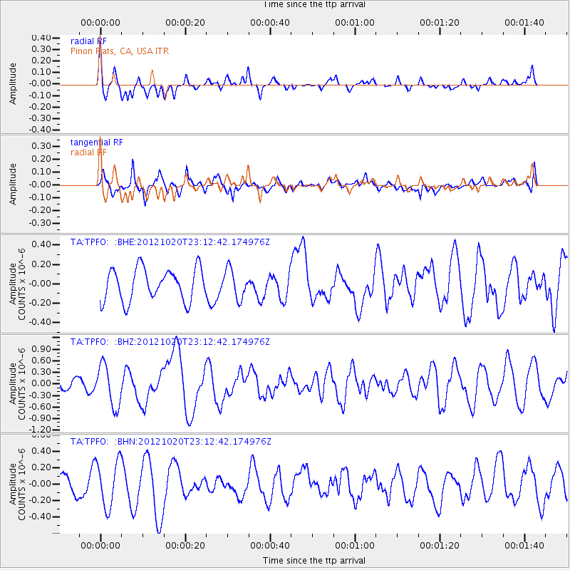
TPFO Pinon Flats, CA, USA - Earthquake Result Viewer
*The percent match for this event was below the threshold and hence no stack was calculated.
| Earthquake location: |
Vanuatu Islands |
| Earthquake latitude/longitude: |
-13.6/166.6 |
| Earthquake time(UTC): |
2012/10/20 (294) 23:00:32 GMT |
| Earthquake Depth: |
36 km |
| Earthquake Magnitude: |
5.9 MB, 6.1 MS, 6.2 MW, 6.2 MW |
| Earthquake Catalog/Contributor: |
WHDF/NEIC |
|
| Network: |
TA USArray Transportable Network (new EarthScope stations) |
| Station: |
TPFO Pinon Flats, CA, USA |
| Lat/Lon: |
33.61 N/116.45 W |
| Elevation: |
1275 m |
|
| Distance: |
86.9 deg |
| Az: |
54.521 deg |
| Baz: |
251.61 deg |
| Ray Param: |
$rayparam |
*The percent match for this event was below the threshold and hence was not used in the summary stack. |
|
| Radial Match: |
50.47456 % |
| Radial Bump: |
400 |
| Transverse Match: |
66.752205 % |
| Transverse Bump: |
400 |
| SOD ConfigId: |
478790 |
| Insert Time: |
2013-02-23 16:06:18.019 +0000 |
| GWidth: |
2.5 |
| Max Bumps: |
400 |
| Tol: |
0.001 |
|
Signal To Noise
| Channel | StoN | STA | LTA |
| TA:TPFO: :BHZ:20121020T23:12:42.174976Z | 3.6460671 | 5.50971E-7 | 1.5111377E-7 |
| TA:TPFO: :BHN:20121020T23:12:42.174976Z | 1.8961024 | 2.822845E-7 | 1.4887618E-7 |
| TA:TPFO: :BHE:20121020T23:12:42.174976Z | 0.92719936 | 1.5335914E-7 | 1.6540041E-7 |
| Arrivals |
| Ps | |
| PpPs | |
| PsPs/PpSs | |


