You are here: Home > Network List > TA - USArray Transportable Network (new EarthScope stations) Stations List
> Station TOLK Toolik Lake Research Station, AK, USA > Earthquake Result Viewer
TOLK Toolik Lake Research Station, AK, USA - Earthquake Result Viewer
*The percent match for this event was below the threshold and hence no stack was calculated.
| Earthquake location: |
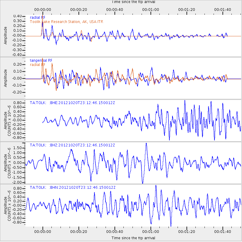
Vanuatu Islands |
| Earthquake latitude/longitude: |
-13.6/166.6 |
| Earthquake time(UTC): |
2012/10/20 (294) 23:00:32 GMT |
| Earthquake Depth: |
36 km |
| Earthquake Magnitude: |
5.9 MB, 6.1 MS, 6.2 MW, 6.2 MW |
| Earthquake Catalog/Contributor: |
WHDF/NEIC |
|
| Network: |
TA USArray Transportable Network (new EarthScope stations) |
| Station: |
TOLK Toolik Lake Research Station, AK, USA |
| Lat/Lon: |
68.64 N/149.57 W |
| Elevation: |
760 m |
|
| Distance: |
87.7 deg |
| Az: |
14.718 deg |
| Baz: |
222.411 deg |
| Ray Param: |
$rayparam |
*The percent match for this event was below the threshold and hence was not used in the summary stack. |
|
| Radial Match: |
77.615616 % |
| Radial Bump: |
400 |
| Transverse Match: |
79.60467 % |
| Transverse Bump: |
400 |
| SOD ConfigId: |
478790 |
| Insert Time: |
2013-02-23 16:07:25.888 +0000 |
| GWidth: |
2.5 |
| Max Bumps: |
400 |
| Tol: |
0.001 |
|
Signal To Noise
| Channel | StoN | STA | LTA |
| TA:TOLK: :BHZ:20121020T23:12:46.150012Z | 3.2076838 | 5.2647374E-7 | 1.6412892E-7 |
| TA:TOLK: :BHN:20121020T23:12:46.150012Z | 0.82840675 | 1.2415869E-7 | 1.4987647E-7 |
| TA:TOLK: :BHE:20121020T23:12:46.150012Z | 1.5197309 | 1.7163258E-7 | 1.1293617E-7 |
| Arrivals |
| Ps | |
| PpPs | |
| PsPs/PpSs | |


