You are here: Home > Network List > TA - USArray Transportable Network (new EarthScope stations) Stations List
> Station P47A Martinsville, IN, USA > Earthquake Result Viewer
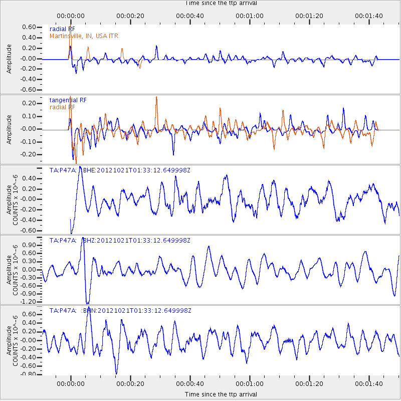
P47A Martinsville, IN, USA - Earthquake Result Viewer
*The percent match for this event was below the threshold and hence no stack was calculated.
| Earthquake location: |
Iceland Region |
| Earthquake latitude/longitude: |
66.3/-18.7 |
| Earthquake time(UTC): |
2012/10/21 (295) 01:25:22 GMT |
| Earthquake Depth: |
10 km |
| Earthquake Magnitude: |
5.5 MW, 5.2 MS, 5.4 MB, 5.6 MW |
| Earthquake Catalog/Contributor: |
WHDF/NEIC |
|
| Network: |
TA USArray Transportable Network (new EarthScope stations) |
| Station: |
P47A Martinsville, IN, USA |
| Lat/Lon: |
39.49 N/86.27 W |
| Elevation: |
246 m |
|
| Distance: |
45.7 deg |
| Az: |
268.896 deg |
| Baz: |
31.47 deg |
| Ray Param: |
$rayparam |
*The percent match for this event was below the threshold and hence was not used in the summary stack. |
|
| Radial Match: |
64.838486 % |
| Radial Bump: |
400 |
| Transverse Match: |
50.330727 % |
| Transverse Bump: |
380 |
| SOD ConfigId: |
478790 |
| Insert Time: |
2013-02-25 03:46:57.704 +0000 |
| GWidth: |
2.5 |
| Max Bumps: |
400 |
| Tol: |
0.001 |
|
Signal To Noise
| Channel | StoN | STA | LTA |
| TA:P47A: :BHZ:20121021T01:33:12.649998Z | 2.1990108 | 5.173183E-7 | 2.3525047E-7 |
| TA:P47A: :BHN:20121021T01:33:12.649998Z | 0.78297454 | 1.7790792E-7 | 2.2722058E-7 |
| TA:P47A: :BHE:20121021T01:33:12.649998Z | 0.8520515 | 1.9859273E-7 | 2.3307598E-7 |
| Arrivals |
| Ps | |
| PpPs | |
| PsPs/PpSs | |


