You are here: Home > Network List > TA - USArray Transportable Network (new EarthScope stations) Stations List
> Station 352A Blakely, GA, USA > Earthquake Result Viewer
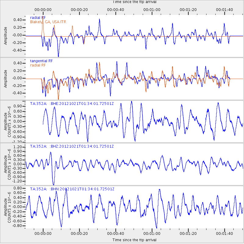
352A Blakely, GA, USA - Earthquake Result Viewer
*The percent match for this event was below the threshold and hence no stack was calculated.
| Earthquake location: |
Iceland Region |
| Earthquake latitude/longitude: |
66.3/-18.7 |
| Earthquake time(UTC): |
2012/10/21 (295) 01:25:22 GMT |
| Earthquake Depth: |
10 km |
| Earthquake Magnitude: |
5.5 MW, 5.2 MS, 5.4 MB, 5.6 MW |
| Earthquake Catalog/Contributor: |
WHDF/NEIC |
|
| Network: |
TA USArray Transportable Network (new EarthScope stations) |
| Station: |
352A Blakely, GA, USA |
| Lat/Lon: |
31.48 N/84.93 W |
| Elevation: |
101 m |
|
| Distance: |
52.1 deg |
| Az: |
262.379 deg |
| Baz: |
27.954 deg |
| Ray Param: |
$rayparam |
*The percent match for this event was below the threshold and hence was not used in the summary stack. |
|
| Radial Match: |
56.068165 % |
| Radial Bump: |
385 |
| Transverse Match: |
54.4877 % |
| Transverse Bump: |
321 |
| SOD ConfigId: |
478790 |
| Insert Time: |
2013-02-25 03:50:34.460 +0000 |
| GWidth: |
2.5 |
| Max Bumps: |
400 |
| Tol: |
0.001 |
|
Signal To Noise
| Channel | StoN | STA | LTA |
| TA:352A: :BHZ:20121021T01:34:01.72501Z | 2.422782 | 3.836032E-7 | 1.583317E-7 |
| TA:352A: :BHN:20121021T01:34:01.72501Z | 0.8213984 | 2.5202863E-7 | 3.0682875E-7 |
| TA:352A: :BHE:20121021T01:34:01.72501Z | 0.7006433 | 3.351451E-7 | 4.7833913E-7 |
| Arrivals |
| Ps | |
| PpPs | |
| PsPs/PpSs | |


