You are here: Home > Network List > G - GEOSCOPE Stations List
> Station WUS Wushi, Xinjiang Uygur, China > Earthquake Result Viewer
WUS Wushi, Xinjiang Uygur, China - Earthquake Result Viewer

| Earthquake location: |
New Ireland Region, P.N.G. |
| Earthquake latitude/longitude: |
-4.0/152.2 |
| Earthquake time(UTC): |
2000/11/16 (321) 04:54:56 GMT |
| Earthquake Depth: |
33 km |
| Earthquake Magnitude: |
6.0 MB, 8.2 MS, 8.0 MW, 8.0 ME |
| Earthquake Catalog/Contributor: |
WHDF/NEIC |
|
| Network: |
G GEOSCOPE |
| Station: |
WUS Wushi, Xinjiang Uygur, China |
| Lat/Lon: |
41.20 N/79.22 E |
| Elevation: |
1457 m |
|
| Distance: |
79.9 deg |
| Az: |
312.876 deg |
| Baz: |
104.347 deg |
| Ray Param: |
0.048603725 |
| Estimated Moho Depth: |
50.25 km |
| Estimated Crust Vp/Vs: |
1.79 |
| Assumed Crust Vp: |
6.353 km/s |
| Estimated Crust Vs: |
3.554 km/s |
| Estimated Crust Poisson's Ratio: |
0.27 |
|
| Radial Match: |
95.59802 % |
| Radial Bump: |
356 |
| Transverse Match: |
79.68715 % |
| Transverse Bump: |
400 |
| SOD ConfigId: |
3744 |
| Insert Time: |
2010-02-27 01:02:55.755 +0000 |
| GWidth: |
2.5 |
| Max Bumps: |
400 |
| Tol: |
0.001 |
|
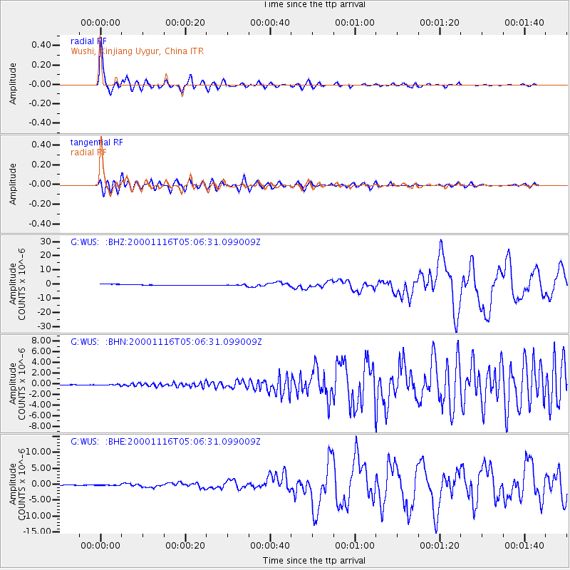
Signal To Noise
| Channel | StoN | STA | LTA |
| G:WUS: :BHN:20001116T05:06:31.099009Z | 2.1433215 | 7.81115E-8 | 3.6444135E-8 |
| G:WUS: :BHE:20001116T05:06:31.099009Z | 0.9114496 | 1.1221767E-7 | 1.2312E-7 |
| G:WUS: :BHZ:20001116T05:06:31.099009Z | 1.4555148 | 4.4971057E-7 | 3.089701E-7 |
| Arrivals |
| Ps | 6.4 SECOND |
| PpPs | 21 SECOND |
| PsPs/PpSs | 28 SECOND |


