You are here: Home > Network List > PR - Puerto Rico Seismic Network (PRSN) & Puerto Rico Strong Motion Program (PRSMP) Stations List
> Station MLPR Magueyes > Earthquake Result Viewer
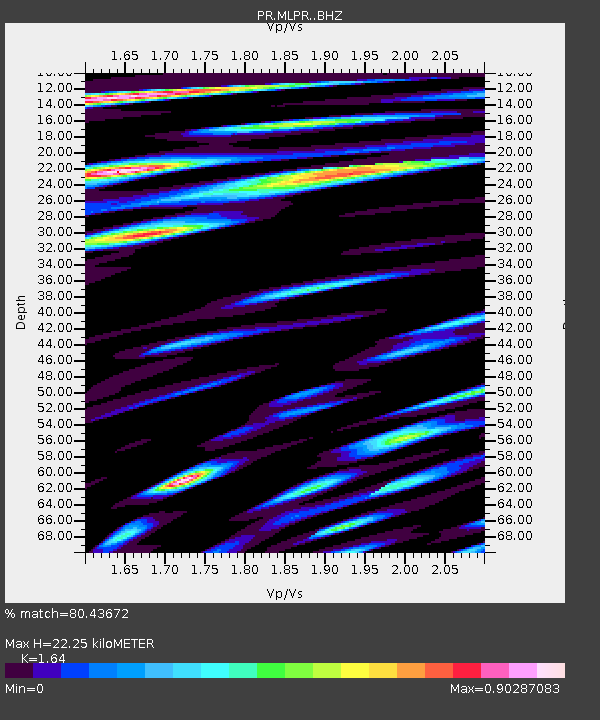
MLPR Magueyes - Earthquake Result Viewer
| Earthquake location: |
Near Coast Of Northern Chile |
| Earthquake latitude/longitude: |
-20.0/-70.9 |
| Earthquake time(UTC): |
2014/06/19 (170) 09:38:37 GMT |
| Earthquake Depth: |
19 km |
| Earthquake Magnitude: |
5.7 MWP |
| Earthquake Catalog/Contributor: |
NEIC PDE/NEIC COMCAT |
|
| Network: |
PR Puerto Rico Seismic Network (PRSN) & Puerto Rico Strong Motion Program (PRSMP) |
| Station: |
MLPR Magueyes |
| Lat/Lon: |
17.97 N/67.04 W |
| Elevation: |
0.0 m |
|
| Distance: |
37.9 deg |
| Az: |
6.045 deg |
| Baz: |
185.973 deg |
| Ray Param: |
0.075856365 |
| Estimated Moho Depth: |
22.25 km |
| Estimated Crust Vp/Vs: |
1.64 |
| Assumed Crust Vp: |
4.082 km/s |
| Estimated Crust Vs: |
2.489 km/s |
| Estimated Crust Poisson's Ratio: |
0.20 |
|
| Radial Match: |
80.43672 % |
| Radial Bump: |
400 |
| Transverse Match: |
58.69081 % |
| Transverse Bump: |
400 |
| SOD ConfigId: |
3390531 |
| Insert Time: |
2019-04-12 08:24:47.379 +0000 |
| GWidth: |
2.5 |
| Max Bumps: |
400 |
| Tol: |
0.001 |
|

Signal To Noise
| Channel | StoN | STA | LTA |
| PR:MLPR: :BHZ:20140619T09:45:22.145009Z | 5.659318 | 8.8027133E-7 | 1.5554372E-7 |
| PR:MLPR: :BHN:20140619T09:45:22.145009Z | 2.3507314 | 3.6360063E-7 | 1.5467553E-7 |
| PR:MLPR: :BHE:20140619T09:45:22.145009Z | 1.31594 | 2.0444428E-7 | 1.5535988E-7 |
| Arrivals |
| Ps | 3.6 SECOND |
| PpPs | 14 SECOND |
| PsPs/PpSs | 18 SECOND |


