You are here: Home > Network List > G - GEOSCOPE Stations List
> Station WUS Wushi, Xinjiang Uygur, China > Earthquake Result Viewer
WUS Wushi, Xinjiang Uygur, China - Earthquake Result Viewer

| Earthquake location: |
Seram, Indonesia |
| Earthquake latitude/longitude: |
-4.0/127.3 |
| Earthquake time(UTC): |
2000/08/28 (241) 15:38:06 GMT |
| Earthquake Depth: |
10 km |
| Earthquake Magnitude: |
5.8 MB, 5.8 MS, 6.1 MW |
| Earthquake Catalog/Contributor: |
WHDF/NEIC |
|
| Network: |
G GEOSCOPE |
| Station: |
WUS Wushi, Xinjiang Uygur, China |
| Lat/Lon: |
41.20 N/79.22 E |
| Elevation: |
1457 m |
|
| Distance: |
62.8 deg |
| Az: |
320.826 deg |
| Baz: |
123.376 deg |
| Ray Param: |
0.060001735 |
| Estimated Moho Depth: |
10.0 km |
| Estimated Crust Vp/Vs: |
1.60 |
| Assumed Crust Vp: |
6.353 km/s |
| Estimated Crust Vs: |
3.964 km/s |
| Estimated Crust Poisson's Ratio: |
0.18 |
|
| Radial Match: |
94.84577 % |
| Radial Bump: |
341 |
| Transverse Match: |
73.980316 % |
| Transverse Bump: |
400 |
| SOD ConfigId: |
3744 |
| Insert Time: |
2010-02-27 01:03:07.186 +0000 |
| GWidth: |
2.5 |
| Max Bumps: |
400 |
| Tol: |
0.001 |
|
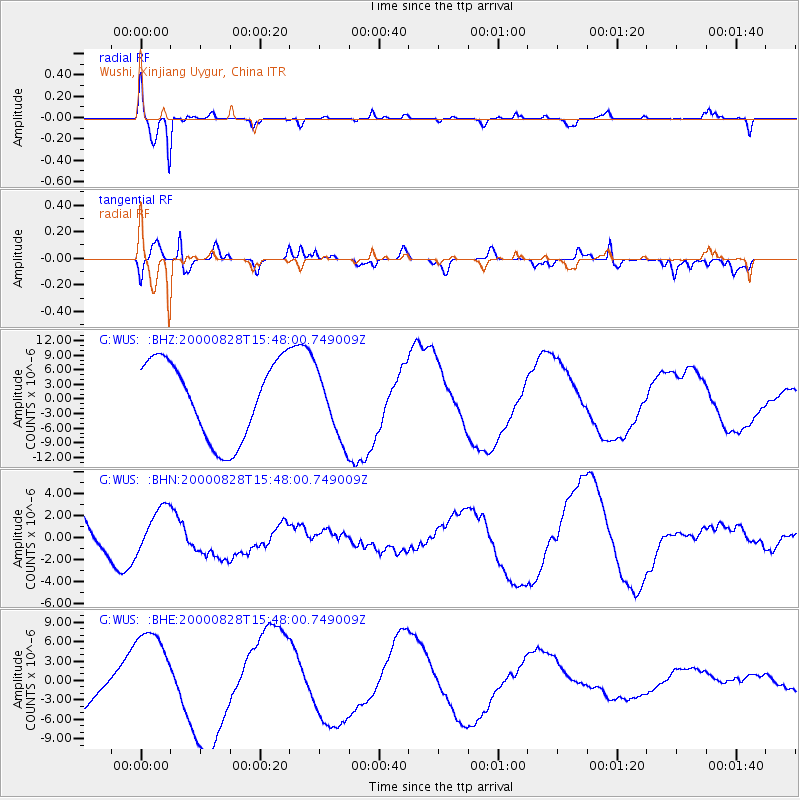
Signal To Noise
| Channel | StoN | STA | LTA |
| G:WUS: :BHN:20000828T15:48:00.749009Z | 1.2459239 | 2.2526858E-6 | 1.8080445E-6 |
| G:WUS: :BHE:20000828T15:48:00.749009Z | 1.8101972 | 7.3297497E-6 | 4.049144E-6 |
| G:WUS: :BHZ:20000828T15:48:00.749009Z | 0.858788 | 6.9068483E-6 | 8.042553E-6 |
| Arrivals |
| Ps | 1.0 SECOND |
| PpPs | 3.9 SECOND |
| PsPs/PpSs | 4.9 SECOND |


