You are here: Home > Network List > CI - Caltech Regional Seismic Network Stations List
> Station MPP McPhearson Peak > Earthquake Result Viewer
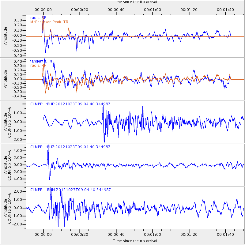
MPP McPhearson Peak - Earthquake Result Viewer
*The percent match for this event was below the threshold and hence no stack was calculated.
| Earthquake location: |
Southeast Of Honshu, Japan |
| Earthquake latitude/longitude: |
29.1/139.3 |
| Earthquake time(UTC): |
2012/10/23 (297) 08:53:38 GMT |
| Earthquake Depth: |
436 km |
| Earthquake Magnitude: |
6.0 MB, 5.9 MW, 6.0 MW |
| Earthquake Catalog/Contributor: |
WHDF/NEIC |
|
| Network: |
CI Caltech Regional Seismic Network |
| Station: |
MPP McPhearson Peak |
| Lat/Lon: |
34.89 N/119.81 W |
| Elevation: |
1739 m |
|
| Distance: |
82.0 deg |
| Az: |
54.587 deg |
| Baz: |
299.774 deg |
| Ray Param: |
$rayparam |
*The percent match for this event was below the threshold and hence was not used in the summary stack. |
|
| Radial Match: |
69.39939 % |
| Radial Bump: |
400 |
| Transverse Match: |
63.544655 % |
| Transverse Bump: |
400 |
| SOD ConfigId: |
478790 |
| Insert Time: |
2013-02-25 14:08:15.081 +0000 |
| GWidth: |
2.5 |
| Max Bumps: |
400 |
| Tol: |
0.001 |
|
Signal To Noise
| Channel | StoN | STA | LTA |
| CI:MPP: :BHZ:20121023T09:04:40.34498Z | 7.2637596 | 1.899417E-6 | 2.6149226E-7 |
| CI:MPP: :BHN:20121023T09:04:40.34498Z | 3.2059963 | 8.392685E-7 | 2.6178088E-7 |
| CI:MPP: :BHE:20121023T09:04:40.34498Z | 2.7891574 | 8.606425E-7 | 3.085672E-7 |
| Arrivals |
| Ps | |
| PpPs | |
| PsPs/PpSs | |


