You are here: Home > Network List > MY - Malaysian National Seismic Network Stations List
> Station KOM Kota Tinggi > Earthquake Result Viewer
KOM Kota Tinggi - Earthquake Result Viewer
| Earthquake location: |
Southeast Of Honshu, Japan |
| Earthquake latitude/longitude: |
29.1/139.3 |
| Earthquake time(UTC): |
2012/10/23 (297) 08:53:38 GMT |
| Earthquake Depth: |
436 km |
| Earthquake Magnitude: |
6.0 MB, 5.9 MW, 6.0 MW |
| Earthquake Catalog/Contributor: |
WHDF/NEIC |
|
| Network: |
MY Malaysian National Seismic Network |
| Station: |
KOM Kota Tinggi |
| Lat/Lon: |
1.79 N/103.85 E |
| Elevation: |
49 m |
|
| Distance: |
43.3 deg |
| Az: |
237.673 deg |
| Baz: |
47.746 deg |
| Ray Param: |
0.07068298 |
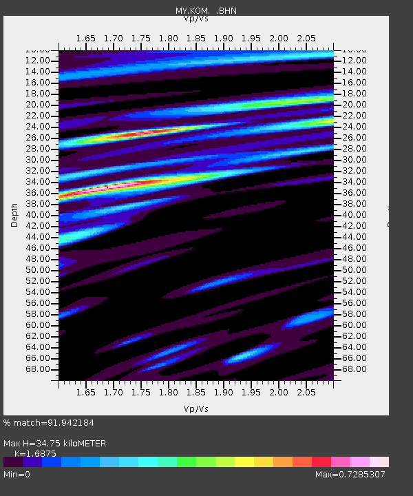
| Estimated Moho Depth: |
34.75 km |
| Estimated Crust Vp/Vs: |
1.69 |
| Assumed Crust Vp: |
6.24 km/s |
| Estimated Crust Vs: |
3.698 km/s |
| Estimated Crust Poisson's Ratio: |
0.23 |
|
| Radial Match: |
91.942184 % |
| Radial Bump: |
400 |
| Transverse Match: |
75.26389 % |
| Transverse Bump: |
400 |
| SOD ConfigId: |
478790 |
| Insert Time: |
2013-02-25 14:17:28.732 +0000 |
| GWidth: |
2.5 |
| Max Bumps: |
400 |
| Tol: |
0.001 |
|

Signal To Noise
| Channel | StoN | STA | LTA |
| MY:KOM: :BHZ:20121023T09:00:28.919993Z | 24.337605 | 2.5831737E-6 | 1.0613919E-7 |
| MY:KOM: :BHN:20121023T09:00:28.919993Z | 7.9296994 | 9.202615E-7 | 1.1605251E-7 |
| MY:KOM: :BHE:20121023T09:00:28.919993Z | 9.877454 | 1.0435173E-6 | 1.0564638E-7 |
| Arrivals |
| Ps | 4.1 SECOND |
| PpPs | 14 SECOND |
| PsPs/PpSs | 18 SECOND |


