You are here: Home > Network List > TA - USArray Transportable Network (new EarthScope stations) Stations List
> Station L39A Vinton, IA, USA > Earthquake Result Viewer
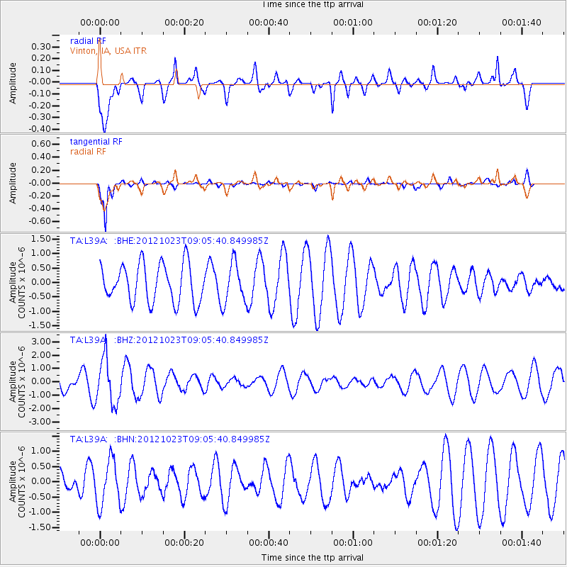
L39A Vinton, IA, USA - Earthquake Result Viewer
*The percent match for this event was below the threshold and hence no stack was calculated.
| Earthquake location: |
Southeast Of Honshu, Japan |
| Earthquake latitude/longitude: |
29.1/139.3 |
| Earthquake time(UTC): |
2012/10/23 (297) 08:53:38 GMT |
| Earthquake Depth: |
436 km |
| Earthquake Magnitude: |
6.0 MB, 5.9 MW, 6.0 MW |
| Earthquake Catalog/Contributor: |
WHDF/NEIC |
|
| Network: |
TA USArray Transportable Network (new EarthScope stations) |
| Station: |
L39A Vinton, IA, USA |
| Lat/Lon: |
42.12 N/92.00 W |
| Elevation: |
261 m |
|
| Distance: |
94.9 deg |
| Az: |
35.612 deg |
| Baz: |
316.742 deg |
| Ray Param: |
$rayparam |
*The percent match for this event was below the threshold and hence was not used in the summary stack. |
|
| Radial Match: |
51.55192 % |
| Radial Bump: |
400 |
| Transverse Match: |
92.60033 % |
| Transverse Bump: |
280 |
| SOD ConfigId: |
478790 |
| Insert Time: |
2013-02-25 14:25:35.891 +0000 |
| GWidth: |
2.5 |
| Max Bumps: |
400 |
| Tol: |
0.001 |
|
Signal To Noise
| Channel | StoN | STA | LTA |
| TA:L39A: :BHZ:20121023T09:05:40.849985Z | 3.126039 | 1.712889E-6 | 5.4794225E-7 |
| TA:L39A: :BHN:20121023T09:05:40.849985Z | 2.4139364 | 7.5796316E-7 | 3.1399466E-7 |
| TA:L39A: :BHE:20121023T09:05:40.849985Z | 1.0686678 | 7.0141E-7 | 6.5634055E-7 |
| Arrivals |
| Ps | |
| PpPs | |
| PsPs/PpSs | |


