You are here: Home > Network List > TA - USArray Transportable Network (new EarthScope stations) Stations List
> Station O03E Paynes Creek, CA, USA > Earthquake Result Viewer
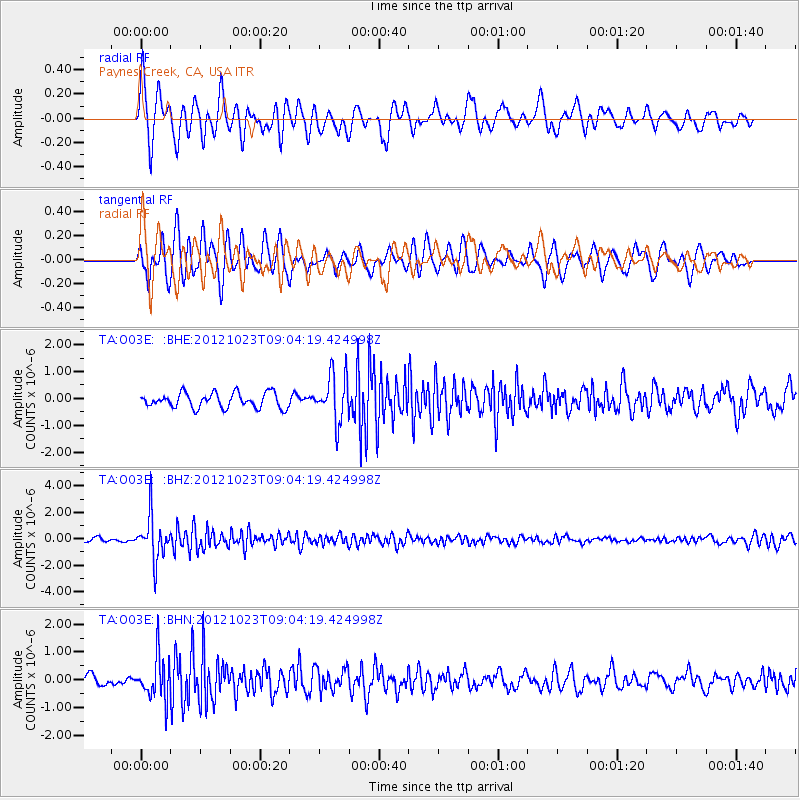
O03E Paynes Creek, CA, USA - Earthquake Result Viewer
*The percent match for this event was below the threshold and hence no stack was calculated.
| Earthquake location: |
Southeast Of Honshu, Japan |
| Earthquake latitude/longitude: |
29.1/139.3 |
| Earthquake time(UTC): |
2012/10/23 (297) 08:53:38 GMT |
| Earthquake Depth: |
436 km |
| Earthquake Magnitude: |
6.0 MB, 5.9 MW, 6.0 MW |
| Earthquake Catalog/Contributor: |
WHDF/NEIC |
|
| Network: |
TA USArray Transportable Network (new EarthScope stations) |
| Station: |
O03E Paynes Creek, CA, USA |
| Lat/Lon: |
40.29 N/121.80 W |
| Elevation: |
967 m |
|
| Distance: |
78.0 deg |
| Az: |
50.562 deg |
| Baz: |
297.867 deg |
| Ray Param: |
$rayparam |
*The percent match for this event was below the threshold and hence was not used in the summary stack. |
|
| Radial Match: |
77.78751 % |
| Radial Bump: |
400 |
| Transverse Match: |
72.48017 % |
| Transverse Bump: |
400 |
| SOD ConfigId: |
478790 |
| Insert Time: |
2013-02-25 14:27:22.672 +0000 |
| GWidth: |
2.5 |
| Max Bumps: |
400 |
| Tol: |
0.001 |
|
Signal To Noise
| Channel | StoN | STA | LTA |
| TA:O03E: :BHZ:20121023T09:04:19.424998Z | 13.536553 | 1.6556577E-6 | 1.2231013E-7 |
| TA:O03E: :BHN:20121023T09:04:19.424998Z | 4.0361543 | 7.684771E-7 | 1.9039832E-7 |
| TA:O03E: :BHE:20121023T09:04:19.424998Z | 3.1687155 | 8.7210367E-7 | 2.752231E-7 |
| Arrivals |
| Ps | |
| PpPs | |
| PsPs/PpSs | |


