You are here: Home > Network List > TA - USArray Transportable Network (new EarthScope stations) Stations List
> Station J01E Myrtle Point, OR, USA > Earthquake Result Viewer
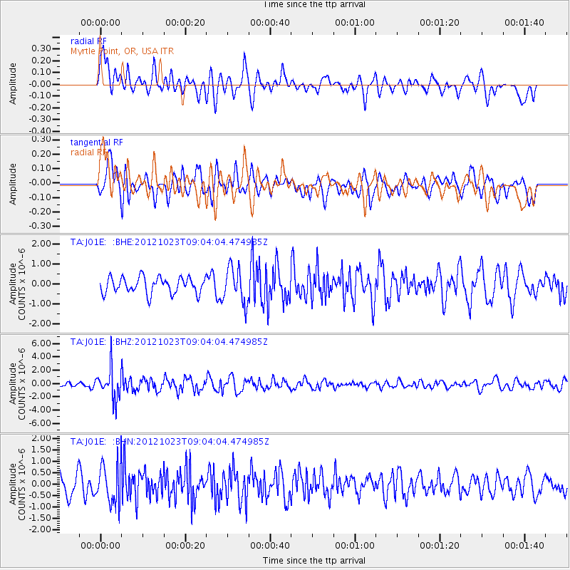
J01E Myrtle Point, OR, USA - Earthquake Result Viewer
*The percent match for this event was below the threshold and hence no stack was calculated.
| Earthquake location: |
Southeast Of Honshu, Japan |
| Earthquake latitude/longitude: |
29.1/139.3 |
| Earthquake time(UTC): |
2012/10/23 (297) 08:53:38 GMT |
| Earthquake Depth: |
436 km |
| Earthquake Magnitude: |
6.0 MB, 5.9 MW, 6.0 MW |
| Earthquake Catalog/Contributor: |
WHDF/NEIC |
|
| Network: |
TA USArray Transportable Network (new EarthScope stations) |
| Station: |
J01E Myrtle Point, OR, USA |
| Lat/Lon: |
43.16 N/123.93 W |
| Elevation: |
128 m |
|
| Distance: |
75.3 deg |
| Az: |
48.68 deg |
| Baz: |
296.021 deg |
| Ray Param: |
$rayparam |
*The percent match for this event was below the threshold and hence was not used in the summary stack. |
|
| Radial Match: |
62.505592 % |
| Radial Bump: |
400 |
| Transverse Match: |
54.785595 % |
| Transverse Bump: |
400 |
| SOD ConfigId: |
478790 |
| Insert Time: |
2013-02-25 14:27:45.200 +0000 |
| GWidth: |
2.5 |
| Max Bumps: |
400 |
| Tol: |
0.001 |
|
Signal To Noise
| Channel | StoN | STA | LTA |
| TA:J01E: :BHZ:20121023T09:04:04.474985Z | 6.7846713 | 2.2845834E-6 | 3.367272E-7 |
| TA:J01E: :BHN:20121023T09:04:04.474985Z | 1.8555186 | 8.7454254E-7 | 4.7131974E-7 |
| TA:J01E: :BHE:20121023T09:04:04.474985Z | 2.215565 | 9.0094943E-7 | 4.0664546E-7 |
| Arrivals |
| Ps | |
| PpPs | |
| PsPs/PpSs | |


