You are here: Home > Network List > 1U - Mt. Paektu Seismic Network Stations List
> Station PDBD Paektu Bridge > Earthquake Result Viewer
PDBD Paektu Bridge - Earthquake Result Viewer
| Earthquake location: |
Vanuatu Islands |
| Earthquake latitude/longitude: |
-13.6/166.8 |
| Earthquake time(UTC): |
2014/06/19 (170) 10:17:58 GMT |
| Earthquake Depth: |
60 km |
| Earthquake Magnitude: |
6.4 MWP |
| Earthquake Catalog/Contributor: |
NEIC PDE/NEIC COMCAT |
|
| Network: |
1U Mt. Paektu Seismic Network |
| Station: |
PDBD Paektu Bridge |
| Lat/Lon: |
41.99 N/128.13 E |
| Elevation: |
2164 m |
|
| Distance: |
65.8 deg |
| Az: |
329.259 deg |
| Baz: |
138.186 deg |
| Ray Param: |
0.05791397 |
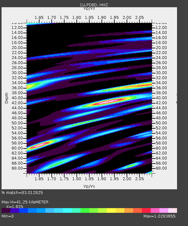
| Estimated Moho Depth: |
41.25 km |
| Estimated Crust Vp/Vs: |
1.92 |
| Assumed Crust Vp: |
6.472 km/s |
| Estimated Crust Vs: |
3.362 km/s |
| Estimated Crust Poisson's Ratio: |
0.32 |
|
| Radial Match: |
83.012825 % |
| Radial Bump: |
400 |
| Transverse Match: |
61.466248 % |
| Transverse Bump: |
400 |
| SOD ConfigId: |
3390531 |
| Insert Time: |
2019-04-12 08:28:46.074 +0000 |
| GWidth: |
2.5 |
| Max Bumps: |
400 |
| Tol: |
0.001 |
|

Signal To Noise
| Channel | StoN | STA | LTA |
| 1U:PDBD: :HHZ:20140619T10:28:06.170015Z | 18.216488 | 1.8312925E-6 | 1.0052939E-7 |
| 1U:PDBD: :HHN:20140619T10:28:06.170015Z | 7.3676624 | 9.930988E-7 | 1.3479156E-7 |
| 1U:PDBD: :HHE:20140619T10:28:06.170015Z | 3.9217002 | 7.0277366E-7 | 1.7920127E-7 |
| Arrivals |
| Ps | 6.1 SECOND |
| PpPs | 18 SECOND |
| PsPs/PpSs | 24 SECOND |


