You are here: Home > Network List > UW - Pacific Northwest Regional Seismic Network Stations List
> Station MRBL Marblemount, WA, USA > Earthquake Result Viewer
MRBL Marblemount, WA, USA - Earthquake Result Viewer
*The percent match for this event was below the threshold and hence no stack was calculated.
| Earthquake location: |
Southeast Of Honshu, Japan |
| Earthquake latitude/longitude: |
29.1/139.3 |
| Earthquake time(UTC): |
2012/10/23 (297) 08:53:38 GMT |
| Earthquake Depth: |
436 km |
| Earthquake Magnitude: |
6.0 MB, 5.9 MW, 6.0 MW |
| Earthquake Catalog/Contributor: |
WHDF/NEIC |
|
| Network: |
UW Pacific Northwest Regional Seismic Network |
| Station: |
MRBL Marblemount, WA, USA |
| Lat/Lon: |
48.52 N/121.48 W |
| Elevation: |
75 m |
|
| Distance: |
74.5 deg |
| Az: |
42.919 deg |
| Baz: |
296.272 deg |
| Ray Param: |
$rayparam |
*The percent match for this event was below the threshold and hence was not used in the summary stack. |
|
| Radial Match: |
58.09285 % |
| Radial Bump: |
400 |
| Transverse Match: |
67.754005 % |
| Transverse Bump: |
400 |
| SOD ConfigId: |
478790 |
| Insert Time: |
2013-02-25 14:30:30.025 +0000 |
| GWidth: |
2.5 |
| Max Bumps: |
400 |
| Tol: |
0.001 |
|
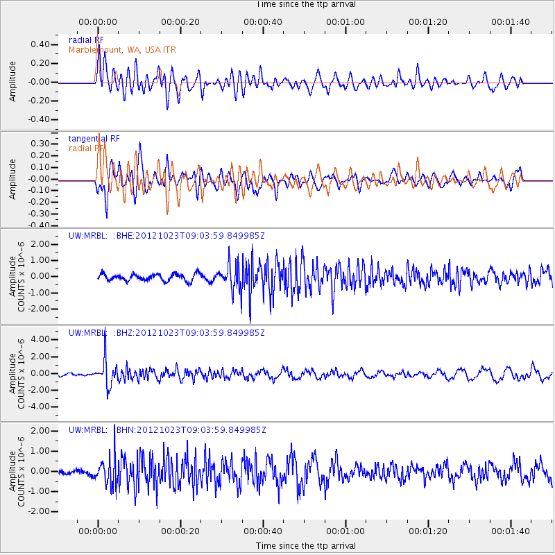
Signal To Noise
| Channel | StoN | STA | LTA |
| UW:MRBL: :BHZ:20121023T09:03:59.849985Z | 7.8452077 | 1.5788341E-6 | 2.0124821E-7 |
| UW:MRBL: :BHN:20121023T09:03:59.849985Z | 4.4716954 | 6.7294013E-7 | 1.5048882E-7 |
| UW:MRBL: :BHE:20121023T09:03:59.849985Z | 3.7903438 | 7.824424E-7 | 2.0643046E-7 |
| Arrivals |
| Ps | |
| PpPs | |
| PsPs/PpSs | |


