You are here: Home > Network List > UW - Pacific Northwest Regional Seismic Network Stations List
> Station LEBA Lebam, WA, USA > Earthquake Result Viewer
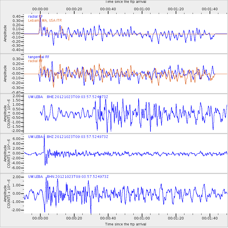
LEBA Lebam, WA, USA - Earthquake Result Viewer
*The percent match for this event was below the threshold and hence no stack was calculated.
| Earthquake location: |
Southeast Of Honshu, Japan |
| Earthquake latitude/longitude: |
29.1/139.3 |
| Earthquake time(UTC): |
2012/10/23 (297) 08:53:38 GMT |
| Earthquake Depth: |
436 km |
| Earthquake Magnitude: |
6.0 MB, 5.9 MW, 6.0 MW |
| Earthquake Catalog/Contributor: |
WHDF/NEIC |
|
| Network: |
UW Pacific Northwest Regional Seismic Network |
| Station: |
LEBA Lebam, WA, USA |
| Lat/Lon: |
46.55 N/123.56 W |
| Elevation: |
73 m |
|
| Distance: |
74.1 deg |
| Az: |
45.402 deg |
| Baz: |
295.415 deg |
| Ray Param: |
$rayparam |
*The percent match for this event was below the threshold and hence was not used in the summary stack. |
|
| Radial Match: |
60.84212 % |
| Radial Bump: |
400 |
| Transverse Match: |
65.76503 % |
| Transverse Bump: |
400 |
| SOD ConfigId: |
478790 |
| Insert Time: |
2013-02-25 14:30:52.941 +0000 |
| GWidth: |
2.5 |
| Max Bumps: |
400 |
| Tol: |
0.001 |
|
Signal To Noise
| Channel | StoN | STA | LTA |
| UW:LEBA: :BHZ:20121023T09:03:57.524973Z | 7.9320145 | 2.3775995E-6 | 2.9974723E-7 |
| UW:LEBA: :BHN:20121023T09:03:57.524973Z | 2.5268457 | 9.232502E-7 | 3.6537654E-7 |
| UW:LEBA: :BHE:20121023T09:03:57.524973Z | 1.7691445 | 7.357383E-7 | 4.158724E-7 |
| Arrivals |
| Ps | |
| PpPs | |
| PsPs/PpSs | |


