You are here: Home > Network List > CB - China National Seismic Network Stations List
> Station WHN Wuhantai,Hubei Province > Earthquake Result Viewer
WHN Wuhantai,Hubei Province - Earthquake Result Viewer
| Earthquake location: |
Vanuatu Islands |
| Earthquake latitude/longitude: |
-13.6/166.8 |
| Earthquake time(UTC): |
2014/06/19 (170) 10:17:58 GMT |
| Earthquake Depth: |
60 km |
| Earthquake Magnitude: |
6.4 MWP |
| Earthquake Catalog/Contributor: |
NEIC PDE/NEIC COMCAT |
|
| Network: |
CB China National Seismic Network |
| Station: |
WHN Wuhantai,Hubei Province |
| Lat/Lon: |
30.54 N/114.35 E |
| Elevation: |
80 m |
|
| Distance: |
66.9 deg |
| Az: |
311.918 deg |
| Baz: |
122.997 deg |
| Ray Param: |
0.057204243 |
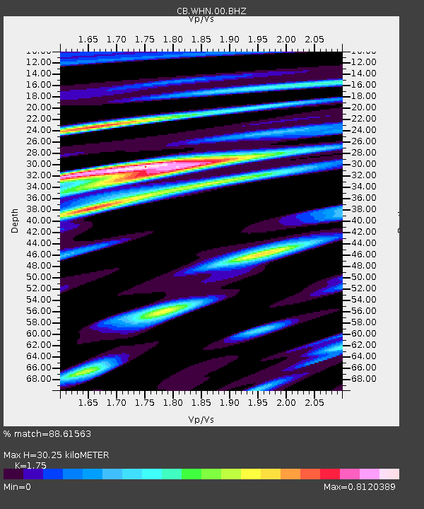
| Estimated Moho Depth: |
30.25 km |
| Estimated Crust Vp/Vs: |
1.75 |
| Assumed Crust Vp: |
6.276 km/s |
| Estimated Crust Vs: |
3.586 km/s |
| Estimated Crust Poisson's Ratio: |
0.26 |
|
| Radial Match: |
88.61563 % |
| Radial Bump: |
221 |
| Transverse Match: |
81.830536 % |
| Transverse Bump: |
383 |
| SOD ConfigId: |
3390531 |
| Insert Time: |
2019-04-12 08:29:34.088 +0000 |
| GWidth: |
2.5 |
| Max Bumps: |
400 |
| Tol: |
0.001 |
|

Signal To Noise
| Channel | StoN | STA | LTA |
| CB:WHN:00:BHZ:20140619T10:28:13.01999Z | 30.094742 | 2.9700564E-6 | 9.8690215E-8 |
| CB:WHN:00:BHN:20140619T10:28:13.01999Z | 4.5548315 | 6.5064916E-7 | 1.4284814E-7 |
| CB:WHN:00:BHE:20140619T10:28:13.01999Z | 7.0196495 | 8.9946917E-7 | 1.2813591E-7 |
| Arrivals |
| Ps | 3.8 SECOND |
| PpPs | 13 SECOND |
| PsPs/PpSs | 17 SECOND |


