You are here: Home > Network List > BK - Berkeley Digital Seismograph Network Stations List
> Station HUMO Hull Mountain, OR > Earthquake Result Viewer
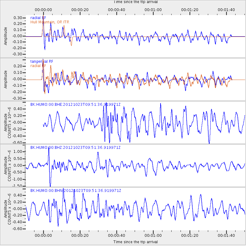
HUMO Hull Mountain, OR - Earthquake Result Viewer
*The percent match for this event was below the threshold and hence no stack was calculated.
| Earthquake location: |
Southeast Of Loyalty Islands |
| Earthquake latitude/longitude: |
-22.3/171.7 |
| Earthquake time(UTC): |
2012/10/23 (297) 09:39:30 GMT |
| Earthquake Depth: |
123 km |
| Earthquake Magnitude: |
5.9 MB, 5.8 MW, 5.9 MW |
| Earthquake Catalog/Contributor: |
WHDF/NEIC |
|
| Network: |
BK Berkeley Digital Seismograph Network |
| Station: |
HUMO Hull Mountain, OR |
| Lat/Lon: |
42.61 N/122.96 W |
| Elevation: |
555 m |
|
| Distance: |
88.3 deg |
| Az: |
42.169 deg |
| Baz: |
237.356 deg |
| Ray Param: |
$rayparam |
*The percent match for this event was below the threshold and hence was not used in the summary stack. |
|
| Radial Match: |
57.231625 % |
| Radial Bump: |
400 |
| Transverse Match: |
38.48658 % |
| Transverse Bump: |
400 |
| SOD ConfigId: |
478790 |
| Insert Time: |
2013-02-25 14:43:07.973 +0000 |
| GWidth: |
2.5 |
| Max Bumps: |
400 |
| Tol: |
0.001 |
|
Signal To Noise
| Channel | StoN | STA | LTA |
| BK:HUMO:00:BHZ:20121023T09:51:36.919971Z | 4.636969 | 6.178614E-7 | 1.3324683E-7 |
| BK:HUMO:00:BHN:20121023T09:51:36.919971Z | 1.2218617 | 1.9299236E-7 | 1.5794943E-7 |
| BK:HUMO:00:BHE:20121023T09:51:36.919971Z | 1.7806368 | 2.5888653E-7 | 1.4538986E-7 |
| Arrivals |
| Ps | |
| PpPs | |
| PsPs/PpSs | |


